|
search place name
|
||
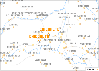
Chico Alto (Piura, Peru)Chico Alto is a town in the Piura region of Peru. An overview map of the region around Chico Alto is displayed below.
regional and 3d topo map of Chico Alto, Peru ::
Chico Alto airports ::
The nearest airport is PIU - Piura Capitan Fap Guillermo Concha Iberico, located 43.3 km south west of Chico Alto.
Other airports nearby include TYL - Talara Capitan Montes (101.2 km west), TBP - Tumbes Pedro Canga (147.2 km north), MCH - Machala General Manuel Serrano (184.9 km north), CIX - Chiclayo Capt Jose A Quinones Gonzales Intl (219.7 km south), Nearby towns ::
Cólera (0.6km west) //
Pedregal (2.2km east) //
Santa Clara (2.6km south) //
Cólera (3.7km north east) //
Pedregal (3.8km south west) //
Pedregal (3.8km south west) //
Sinchi Roca (4.0km west) //
Colera (4.5km east) //
Chico Alto (4.7km south west) //
Manco Inca (4.7km east) //
Colera (4.8km east) //
Ocoto Bajo (5.2km south west) //
Ocoto Alto (6.0km south) //
Huaca Blanca (6.1km south east) //
Angostura (6.8km south) //
Chica Baja (7.1km south west) //
El Cruce (7.1km south east) //
Tambo Grande (7.4km south east) //
El Veintiseis (7.4km north west) //
San Ramón (7.6km south east) //
San Martín de Angostura (7.8km south east) //
Quince Ocho (8.2km north east) //
Somate Alto Doscientos Sesentisiete (8.2km north west) //
Locuto (8.4km south east) //
Hualtaco (8.6km east) //
Huenapira (8.8km south east) //
La Pala (9.5km south east) //
Santa Ana (9.7km south west) //
Hacienda Santa Ana (9.8km south west) //
[all distances 'as the bird flies' and approximate]  Places with similar names to Chico Alto, Peru ::
// Chakalite (BG)
// Chukilite (BG)
// Chikaldy (RU)
// Chuklayda (RU)
// Shacklett (US)
// Chak Kalādia (BD)
// Chhāgaldi (BD)
// Tiakalatou (BJ)
// Chacalluta (CL)
// Chuguldi (CO)
Disclaimer :: Information on this page comes without warranty of any kind |
||
|
Where is Chico Alto? Elevation and coordinates ::
Latitude (lat): 4°53'1"S Longitude (lon): 80°23'42"W
Elevation (approx.): 82m (map arrows pan, magnifying glasses zoom) |
||
|
Visiting Chico Alto? Hotel/Accommodation ::
Book a hotel in Chico Alto Travel Guide ::
Buy a travel guide for Peru rental cars ::
car rental offers GPS waypoint ::
download a GPX waypoint (PoI) of Chico Alto for your GPS receiver
|
||