|
search place name
|
||
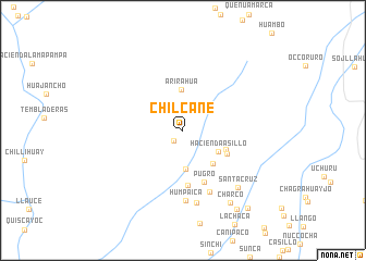
Chilcane (Arequipa, Peru)Chilcane is a town in the Arequipa region of Peru. An overview map of the region around Chilcane is displayed below.
regional and 3d topo map of Chilcane, Peru ::
Chilcane airports ::
The nearest airport is AQP - Arequipa Rodriguez Ballon, located 161.2 km south east of Chilcane.
Other airports nearby include ANS - Andahuaylas (225.3 km north), Nearby towns ::
Sango (1.4km south west) //
Hacienda Canahua (4.0km south) //
Hacienda Asillo (4.1km south east) //
Arirahua (4.2km north) //
Hacienda Cocatijra (4.5km south east) //
Hacienda Asilio (4.6km south east) //
Hacienda Ocoruro (4.9km south east) //
Hacienda Callpay (5.7km south) //
Pugro (5.7km south) //
Ispacas (6.8km south east) //
Humpaica (7.2km south) //
Huallcapampa (7.6km south) //
Santa Cruz (8.0km south east) //
Charco (8.8km south east) //
Chojena (9.7km south east) //
Yanaquihua (10.2km south east) //
[all distances 'as the bird flies' and approximate] 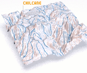 Places with similar names to Chilcane, Peru ::
Disclaimer :: Information on this page comes without warranty of any kind |
||
|
Where is Chilcane? Elevation and coordinates ::
Latitude (lat): 15°42'7"S Longitude (lon): 72°56'10"W
Elevation (approx.): 3299m (map arrows pan, magnifying glasses zoom) |
||
|
Visiting Chilcane? Hotel/Accommodation ::
Book a hotel in Chilcane Travel Guide ::
Buy a travel guide for Peru rental cars ::
car rental offers GPS waypoint ::
download a GPX waypoint (PoI) of Chilcane for your GPS receiver
|
||