|
search place name
|
||
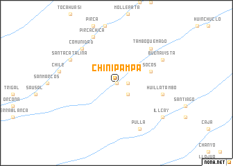
Chinipampa (Ayacucho, Peru)Chinipampa is a town in the Ayacucho region of Peru. An overview map of the region around Chinipampa is displayed below.
regional and 3d topo map of Chinipampa, Peru ::
Chinipampa airports ::
The nearest airport is AYP - Ayacucho Coronel Fap Alfredo Mendivil Duarte, located 189.0 km north of Chinipampa.
Other airports nearby include ANS - Andahuaylas (191.0 km north east), PIO - Pisco Intl (197.3 km north west), Nearby towns ::
Incamaqui (0.0km north) //
Pataraya (0.0km north) //
Ronquillo (1.8km east) //
Uspuna (2.6km south east) //
Moyopampa (5.7km east) //
Socos (5.7km east) //
Huillatambo (7.4km east) //
Comunidad (7.7km north west) //
Tambo Quemado (7.7km north east) //
Buena Vista (8.1km north east) //
Pirca Chica (8.2km north west) //
Pulla (8.2km south east) //
Santa Catalina (8.1km north west) //
Illcay (9.1km south east) //
[all distances 'as the bird flies' and approximate] 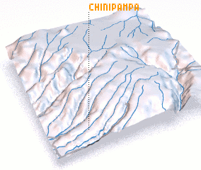 Places with similar names to Chinipampa, Peru :: Disclaimer :: Information on this page comes without warranty of any kind |
||
|
Where is Chinipampa? Elevation and coordinates ::
Latitude (lat): 14°47'0"S Longitude (lon): 74°44'0"W
Elevation (approx.): 1460m (map arrows pan, magnifying glasses zoom) |
||
|
Visiting Chinipampa? Hotel/Accommodation ::
Book a hotel in Chinipampa Travel Guide ::
Buy a travel guide for Peru rental cars ::
car rental offers GPS waypoint ::
download a GPX waypoint (PoI) of Chinipampa for your GPS receiver
|
||