|
search place name
|
||
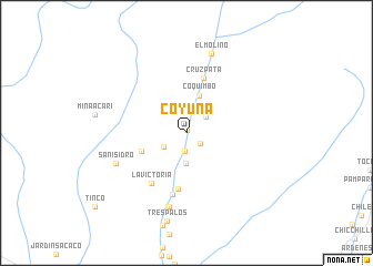
Coyuna (Arequipa, Peru)Coyuna is a town in the Arequipa region of Peru. An overview map of the region around Coyuna is displayed below.
regional and 3d topo map of Coyuna, Peru ::
Coyuna airports ::
The nearest airport is ANS - Andahuaylas, located 234.8 km north east of Coyuna.
Other airports nearby include PIO - Pisco Intl (254.5 km north west), Nearby towns ::
Acarí (0.3km north) //
Sahuacarí (1.7km south east) //
Tambo Viejo (1.9km south) //
Cascajal (2.4km north east) //
Portachuelo (2.6km south west) //
Chocavento (2.7km north) //
Gentilar (3.1km south) //
Coquimbo (4.0km north) //
Bella Unión (4.7km west) //
Cañal (5.7km south) //
Cruz Pata (5.8km north) //
La Victoria (6.1km south west) //
Vijoto (6.3km south) //
Lucasi (7.6km south) //
Lungumarí (7.7km south) //
San Isidro (7.5km south west) //
El Molino (8.3km north) //
Tres Palos (9.1km south) //
[all distances 'as the bird flies' and approximate] 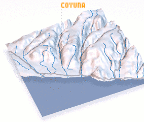 Places with similar names to Coyuna, Peru ::
Disclaimer :: Information on this page comes without warranty of any kind |
||
|
Where is Coyuna? Elevation and coordinates ::
Latitude (lat): 15°26'0"S Longitude (lon): 74°37'0"W
Elevation (approx.): 162m (map arrows pan, magnifying glasses zoom) |
||
|
Visiting Coyuna? Hotel/Accommodation ::
Book a hotel in Coyuna Travel Guide ::
Buy a travel guide for Peru rental cars ::
car rental offers GPS waypoint ::
download a GPX waypoint (PoI) of Coyuna for your GPS receiver
|
||