|
search place name
|
||
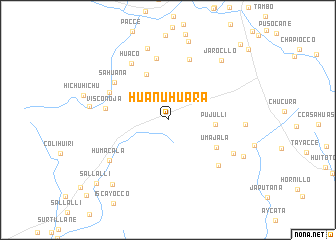
Huanuhuara (Arequipa, Peru)Huanuhuara is a town in the Arequipa region of Peru. An overview map of the region around Huanuhuara is displayed below.
regional and 3d topo map of Huanuhuara, Peru ::
Huanuhuara airports ::
The nearest airport is AQP - Arequipa Rodriguez Ballon, located 64.1 km south of Huanuhuara.
Other airports nearby include JUL - Juliaca (166.4 km east), Nearby towns ::
Pujullí (5.1km east) //
Queñuarane (5.5km north west) //
Umajala (6.0km south east) //
Utunco (7.0km north) //
Visconoja (6.9km west) //
Humajala (7.1km north) //
Huituhuasi (7.0km north west) //
Sahuana (7.1km north west) //
Huaco (7.4km north west) //
Jello Jello (7.4km south east) //
Humacala (7.7km south west) //
Pirichane (7.9km south east) //
Callanja (8.3km north) //
Antasura (8.4km east) //
Hornillo (8.5km west) //
Jarocllo (8.8km north east) //
Cullujane (9.0km north) //
Parcotaña (9.1km south east) //
Parco (9.3km south west) //
Sallalli (10.5km south west) //
Lima Cota (11.5km north east) //
[all distances 'as the bird flies' and approximate] 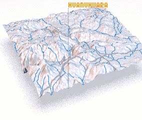 Places with similar names to Huanuhuara, Peru :: Disclaimer :: Information on this page comes without warranty of any kind |
||
|
Where is Huanuhuara? Elevation and coordinates ::
Latitude (lat): 15°46'10"S Longitude (lon): 71°40'41"W
Elevation (approx.): 4733m (map arrows pan, magnifying glasses zoom) |
||
|
Visiting Huanuhuara? Hotel/Accommodation ::
Book a hotel in Huanuhuara Travel Guide ::
Buy a travel guide for Peru rental cars ::
car rental offers GPS waypoint ::
download a GPX waypoint (PoI) of Huanuhuara for your GPS receiver
|
||