|
search place name
|
||
Huara Huito (Arequipa, Peru)Huara Huito is a town in the Arequipa region of Peru. An overview map of the region around Huara Huito is displayed below.
regional and 3d topo map of Huara Huito, Peru ::

Huara Huito airports ::
The nearest airport is AQP - Arequipa Rodriguez Ballon, located 75.9 km south of Huara Huito.
Other airports nearby include JUL - Juliaca (126.9 km east), Nearby towns ::
Chalhuanca (1.5km south west) //
Sanomaña (2.0km south east) //
Sotocaya (3.5km south east) //
Palca (4.0km north) //
Jujumayo (4.3km north east) //
Marcamarca (4.4km south) //
Calcape (4.6km north) //
Yuracmayo (4.8km south west) //
Jayuma (5.1km west) //
Huisca Orco (5.3km south west) //
Andapicho (5.7km north) //
Jatun Orcochiri (6.0km south west) //
Huilcane (6.2km north) //
Chiuchunlaya (6.3km north east) //
Huañapalca (6.6km south) //
Pampa Tonte Pojolla (6.8km north west) //
Huishoro (6.7km west) //
Chingane (6.8km west) //
Japumala (7.3km north) //
Pallallioc (7.1km east) //
Accoma (7.4km south west) //
Llongasora (7.6km north) //
Acopecho (7.4km east) //
Ilpailpa (7.6km west) //
Japutaña (7.8km south east) //
Yanacancha (7.9km east) //
Naquehuiri (8.2km north east) //
Velajro (8.5km north west) //
Totuma (8.4km south east) //
[all distances 'as the bird flies' and approximate] 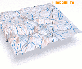 Places with similar names to Huara Huito, Peru ::
Disclaimer :: Information on this page comes without warranty of any kind |
||
|
Where is Huara Huito? Elevation and coordinates ::
Latitude (lat): 15°42'21"S Longitude (lon): 71°18'54"W
Elevation (approx.): 4355m (map arrows pan, magnifying glasses zoom) |
||
|
Visiting Huara Huito? Hotel/Accommodation ::
Book a hotel in Huara Huito Travel Guide ::
Buy a travel guide for Peru rental cars ::
car rental offers GPS waypoint ::
download a GPX waypoint (PoI) of Huara Huito for your GPS receiver
|
||