|
search place name
|
||
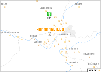
Huaranguillo (Arequipa, Peru)Huaranguillo is a town in the Arequipa region of Peru. An overview map of the region around Huaranguillo is displayed below.
regional and 3d topo map of Huaranguillo, Peru ::
Huaranguillo airports ::
The nearest airport is AQP - Arequipa Rodriguez Ballon, located 8.1 km north of Huaranguillo.
Other airports nearby include JUL - Juliaca (184.8 km north east), TCQ - Tacna Coronel Carlos Ciriani Santa Rosa Intl (228.4 km south east), ARI - Arica Chacalluta (251.5 km south east), Nearby towns ::
Pampa de Camarones (1.2km north east) //
Altos de Amado (1.6km south west) //
Sachaca (1.9km south east) //
Tio Chico (2.0km south) //
Mariscal Castilla (2.1km north) //
Tingo (2.7km south east) //
Pachacutec (3.0km north east) //
Tio Grande (3.1km south west) //
Pampas Nueva (3.1km south west) //
Chila Pampa (3.7km north east) //
Perales (3.8km south west) //
Pampa del Cuzco (4.0km south) //
La Libertad (4.1km north) //
Tiabaya (4.2km south) //
Urbanización Hunter (4.1km south east) //
Cayma (4.1km north east) //
La Apacheta (4.1km east) //
Arequipa (5.1km east) //
Yanahuara (5.2km north east) //
Congata (5.4km south west) //
La Pampilla (5.5km east) //
Urbanización Salaverry (5.7km south east) //
Carmen Pampa (5.9km north east) //
Huayco (5.8km west) //
Bella Pampa (6.1km south east) //
La Tomita (6.4km north east) //
Urbanización Lara (7.0km south east) //
Miraflores (6.9km east) //
El Pasto (7.1km south east) //
[all distances 'as the bird flies' and approximate] 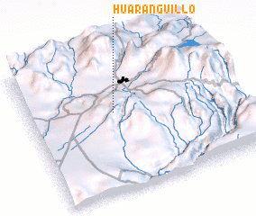 Places with similar names to Huaranguillo, Peru ::
// Hayrangöl (TR)
// Harangul (IN)
// Haranggaul (ID)
// Horno Cal (MX)
// Harangala (LK)
// Harannagala (LK)
// Horangala (LK)
// Horangalla (LK)
// Herānkeleh (IR)
// Huarangal (PE)
Disclaimer :: Information on this page comes without warranty of any kind |
||
|
Where is Huaranguillo? Elevation and coordinates ::
Latitude (lat): 16°24'50"S Longitude (lon): 71°34'47"W
Elevation (approx.): 2267m (map arrows pan, magnifying glasses zoom) |
||
|
Visiting Huaranguillo? Hotel/Accommodation ::
Book a hotel in Huaranguillo Travel Guide ::
Buy a travel guide for Peru rental cars ::
car rental offers GPS waypoint ::
download a GPX waypoint (PoI) of Huaranguillo for your GPS receiver
|
||