|
search place name
|
||
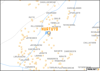
Huatuyo (Puno, Peru)Huatuyo is a town in the Puno region of Peru. An overview map of the region around Huatuyo is displayed below.
regional and 3d topo map of Huatuyo, Peru ::
Huatuyo airports ::
The nearest airport is JUL - Juliaca, located 136.9 km south of Huatuyo.
Other airports nearby include PEM - Puerto Maldonado Padre Aldamiz (195.5 km north), Nearby towns ::
Jatuyo (0.6km west) //
Sucuaylla (1.2km south east) //
Chalo (1.9km north) //
Cerro Jaico (2.1km south west) //
Cieneguilla (2.2km north) //
Sallco (2.7km north west) //
Huasacorral (2.8km north) //
Lechemaco (3.4km south west) //
Mojinete (3.4km north east) //
Ticyacorral (3.6km south) //
Pucucunca (4.0km south) //
Carrizal (4.3km north) //
Tambillo (4.3km north east) //
Chullonquiane (4.7km south) //
Pillcopampa (5.4km north west) //
Saco (5.8km north west) //
Asustadera (5.9km north) //
Pillcopata (5.9km west) //
Colecarca (6.1km north west) //
Quilio (6.2km north east) //
Silicucho (6.3km north) //
Pacchapata (6.3km north) //
Mojinete (6.2km north west) //
Chanatuyo (6.7km south west) //
Jecha Juchu (6.7km south west) //
Carhuapata (6.9km north) //
Jotachaca (7.0km west) //
Sucuaya (7.4km south east) //
Uscuruqui (7.6km north) //
[all distances 'as the bird flies' and approximate]  Places with similar names to Huatuyo, Peru ::
Disclaimer :: Information on this page comes without warranty of any kind |
||
|
Where is Huatuyo? Elevation and coordinates ::
Latitude (lat): 14°15'26"S Longitude (lon): 69°53'32"W
Elevation (approx.): 4523m (map arrows pan, magnifying glasses zoom) |
||
|
Visiting Huatuyo? Hotel/Accommodation ::
Book a hotel in Huatuyo Travel Guide ::
Buy a travel guide for Peru rental cars ::
car rental offers GPS waypoint ::
download a GPX waypoint (PoI) of Huatuyo for your GPS receiver
|
||