|
search place name
|
||
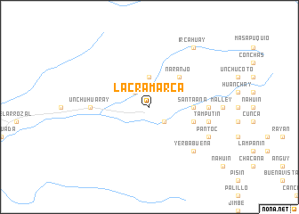
Lacramarca (Ancash, Peru)Lacramarca is a town in the Ancash region of Peru. An overview map of the region around Lacramarca is displayed below.
regional and 3d topo map of Lacramarca, Peru ::
Lacramarca airports ::
The nearest airport is CHM - Chimbote Teniente Jaime A De Montreuil Morales, located 40.8 km south west of Lacramarca.
Other airports nearby include ATA - Anta Comandante Fap German Arias Graziani (89.6 km south east), TRU - Trujillo Capitan Carlos Martinez De Pinillos (128.3 km north west), JJI - Juanjui (254.3 km north east), Nearby towns ::
Lupahuari (2.6km north west) //
Llimpamacay (2.6km south east) //
Cruz Pampa (2.6km south east) //
Apartadero (3.7km north) //
Naranjo (5.2km north east) //
Santa Ana (5.5km east) //
Pachaco (5.8km east) //
Unchuhuaray (7.3km west) //
Bocón (7.3km east) //
Molino (7.3km east) //
Irhua (7.6km east) //
Tamputin (7.6km east) //
Copray (7.8km south east) //
Yerba Buena (7.8km south east) //
Pantoc (8.2km south east) //
Ircahuay (9.2km north east) //
[all distances 'as the bird flies' and approximate] 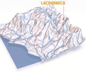 Places with similar names to Lacramarca, Peru :: Disclaimer :: Information on this page comes without warranty of any kind |
||
|
Where is Lacramarca? Elevation and coordinates ::
Latitude (lat): 8°53'0"S Longitude (lon): 78°16'0"W
Elevation (approx.): 896m (map arrows pan, magnifying glasses zoom) |
||
|
Visiting Lacramarca? Hotel/Accommodation ::
Book a hotel in Lacramarca Travel Guide ::
Buy a travel guide for Peru rental cars ::
car rental offers GPS waypoint ::
download a GPX waypoint (PoI) of Lacramarca for your GPS receiver
|
||