|
search place name
|
||
La Puerta de Pedro (Piura, Peru)La Puerta de Pedro is a town in the Piura region of Peru. An overview map of the region around La Puerta de Pedro is displayed below.
regional and 3d topo map of La Puerta de Pedro, Peru ::

La Puerta de Pedro airports ::
The nearest airport is PIU - Piura Capitan Fap Guillermo Concha Iberico, located 49.7 km west of La Puerta de Pedro.
Other airports nearby include TYL - Talara Capitan Montes (144.0 km north west), CIX - Chiclayo Capt Jose A Quinones Gonzales Intl (168.2 km south), TBP - Tumbes Pedro Canga (195.4 km north), Nearby towns ::
Noria La Villegas (4.5km west) //
Hispón (6.0km east) //
El Seis (6.6km north west) //
El Tongo (7.8km north east) //
La Ancajima (8.0km north) //
Silva (9.0km south) //
Casa Blanca (10.9km north east) //
Pabur Hacienda Nueva (12.1km north east) //
[all distances 'as the bird flies' and approximate] 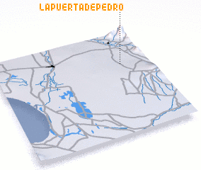 Places with similar names to La Puerta de Pedro, Peru :: Disclaimer :: Information on this page comes without warranty of any kind |
||
|
Where is La Puerta de Pedro? Elevation and coordinates ::
Latitude (lat): 5°18'29"S Longitude (lon): 80°10'48"W
Elevation (approx.): 197m (map arrows pan, magnifying glasses zoom) |
||
|
Visiting La Puerta de Pedro? Hotel/Accommodation ::
Book a hotel in La Puerta de Pedro Travel Guide ::
Buy a travel guide for Peru rental cars ::
car rental offers GPS waypoint ::
download a GPX waypoint (PoI) of La Puerta de Pedro for your GPS receiver
|
||