|
search place name
|
||
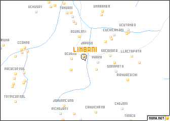
Limbani (Puno, Peru)Limbani is a town in the Puno region of Peru. An overview map of the region around Limbani is displayed below.
regional and 3d topo map of Limbani, Peru ::
Limbani airports ::
The nearest airport is JUL - Juliaca, located 154.5 km south of Limbani.
Other airports nearby include PEM - Puerto Maldonado Padre Aldamiz (176.9 km north), Nearby towns ::
Japaso (2.8km north) //
Phara (2.8km east) //
Ocuara (2.9km west) //
Comunidad (3.1km south east) //
Huancasarani (3.7km south west) //
Agualani (5.4km north) //
Sacarara (5.5km east) //
Ccutine (6.1km north east) //
Jatun Huayjo (6.4km east) //
Sora Pata (7.1km east) //
Uchuy Cutine (7.4km north east) //
Samana Senja (7.5km north east) //
Aquele (8.5km north) //
Cuchi Camani (8.4km north east) //
Llavitira (9.0km north) //
[all distances 'as the bird flies' and approximate] 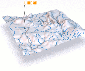 Places with similar names to Limbani, Peru ::
Disclaimer :: Information on this page comes without warranty of any kind |
||
|
Where is Limbani? Elevation and coordinates ::
Latitude (lat): 14°8'52"S Longitude (lon): 69°41'20"W
Elevation (approx.): 3396m (map arrows pan, magnifying glasses zoom) |
||
|
Visiting Limbani? Hotel/Accommodation ::
Book a hotel in Limbani Travel Guide ::
Buy a travel guide for Peru rental cars ::
car rental offers GPS waypoint ::
download a GPX waypoint (PoI) of Limbani for your GPS receiver
|
||