|
search place name
|
||
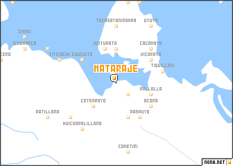
Mataraje (Puno, Peru)Mataraje is a town in the Puno region of Peru. An overview map of the region around Mataraje is displayed below.
regional and 3d topo map of Mataraje, Peru ::
Mataraje airports ::
The nearest airport is JUL - Juliaca, located 60.7 km north west of Mataraje.
Other airports nearby include LPB - La Paz El Alto Intl (187.5 km east), AQP - Arequipa Rodriguez Ballon (193.0 km west), Nearby towns ::
Ocutapampa (1.9km north) //
Platería (2.6km south east) //
Cotempoyo (5.1km south west) //
Calachaca (5.6km north) //
Chapucara (5.8km south) //
Pallalla (5.7km east) //
Huitupata (5.8km north) //
Pampuyo (6.6km south east) //
Acora (6.5km south east) //
Chucuito (6.5km north west) //
Vicaraya (6.5km north east) //
Tiquillani (7.4km east) //
Cacamaya (7.7km north east) //
Huicsapalillana (9.1km south west) //
Ajotapampa (9.0km south west) //
[all distances 'as the bird flies' and approximate] 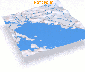 Places with similar names to Mataraje, Peru ::
// Meadow Ridge (US)
// Materaj (AL)
// Mietragi (LV)
// Motorgi (RO)
// Meadowridge (ZA)
// Midridge (US)
// Muttargi (IN)
// Maduarjo (ID)
// Mehdī Rajeh (IR)
// Madrūj (OM)
Disclaimer :: Information on this page comes without warranty of any kind |
||
|
Where is Mataraje? Elevation and coordinates ::
Latitude (lat): 15°55'0"S Longitude (lon): 69°50'0"W
Elevation (approx.): 3819m (map arrows pan, magnifying glasses zoom) |
||
|
Visiting Mataraje? Hotel/Accommodation ::
Book a hotel in Mataraje Travel Guide ::
Buy a travel guide for Peru rental cars ::
car rental offers GPS waypoint ::
download a GPX waypoint (PoI) of Mataraje for your GPS receiver
|
||