|
search place name
|
||
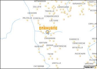
Omahuañe (Cusco, Peru)Omahuañe is a town in the Cusco region of Peru. An overview map of the region around Omahuañe is displayed below.
regional and 3d topo map of Omahuañe, Peru ::
Omahuañe airports ::
The nearest airport is CUZ - Cuzco Teniente Alejandro Velasco Astete Intl, located 102.3 km north west of Omahuañe.
Other airports nearby include JUL - Juliaca (188.0 km south east), ANS - Andahuaylas (215.7 km west), Nearby towns ::
Carañahue (0.9km east) //
Cahuanuyo (1.4km south west) //
Totorani (1.5km north east) //
Huayllane (2.0km east) //
Huampatura (2.2km west) //
Chirupampa (2.5km south) //
Cconequemara (3.2km south east) //
Huacura Pampa (3.2km north west) //
Vaqueria (3.7km north east) //
Ccatun Pampa (3.9km north west) //
Canteria Pampa (3.9km north east) //
Sontura (4.6km south west) //
San Andrés (4.7km south east) //
Lactuire (4.9km north east) //
Itoc Huasi (5.1km north west) //
Quehue (5.2km south) //
Tuyo (5.7km south) //
Pampiyo (6.0km north west) //
Ccaquiracunca (6.2km north) //
Huinchiri (6.6km south west) //
Ccancollo (6.6km north west) //
Canatapucho (6.9km south east) //
Acomayo (7.1km south) //
Yanahuara (7.7km south west) //
Taucollo (8.2km north) //
Cuscuito (8.2km north) //
Apacheta (8.2km north east) //
Tucsa (8.5km south) //
Pucapuca (8.7km north) //
[all distances 'as the bird flies' and approximate] 
Disclaimer :: Information on this page comes without warranty of any kind |
||
|
Where is Omahuañe? Elevation and coordinates ::
Latitude (lat): 14°20'0"S Longitude (lon): 71°27'35"W
Elevation (approx.): 3966m (map arrows pan, magnifying glasses zoom) |
||
|
Visiting Omahuañe? Hotel/Accommodation ::
Book a hotel in Omahuañe Travel Guide ::
Buy a travel guide for Peru rental cars ::
car rental offers GPS waypoint ::
download a GPX waypoint (PoI) of Omahuañe for your GPS receiver
|
||