|
search place name
|
||
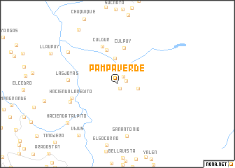
Pampa Verde (La Libertad, Peru)Pampa Verde is a town in the La Libertad region of Peru. An overview map of the region around Pampa Verde is displayed below.
regional and 3d topo map of Pampa Verde, Peru ::
Pampa Verde airports ::
The nearest airport is JJI - Juanjui, located 110.9 km north east of Pampa Verde.
Other airports nearby include CHH - Chachapoyas (162.7 km north), TRU - Trujillo Capitan Carlos Martinez De Pinillos (172.1 km west), TPP - Tarapoto Cadete Guillermo Del Castillo Paredes (186.1 km north east), ATA - Anta Comandante Fap German Arias Graziani (187.5 km south), Nearby towns ::
Macamia (0.9km south east) //
Cativen (1.5km north east) //
Santa Clara (1.5km east) //
Palomar (2.4km north west) //
Lavasen (3.3km east) //
Chuquitambo (3.4km north west) //
Potrero del Rey (4.1km north) //
Huasipampa (5.7km north) //
Culpuy (5.9km north) //
Culgur (6.4km north) //
Hacienda Laredito (7.6km west) //
Las Joyas (7.9km west) //
Shicún (8.0km west) //
San Antonio (8.5km south) //
Hacienda Nimpana (9.3km north west) //
Hacienda Talpito (10.0km south west) //
Vijus (10.3km south west) //
Uchubamba (10.6km north west) //
[all distances 'as the bird flies' and approximate]  Places with similar names to Pampa Verde, Peru ::
Disclaimer :: Information on this page comes without warranty of any kind |
||
|
Where is Pampa Verde? Elevation and coordinates ::
Latitude (lat): 7°39'7"S Longitude (lon): 77°36'33"W
Elevation (approx.): 2506m (map arrows pan, magnifying glasses zoom) |
||
|
Visiting Pampa Verde? Hotel/Accommodation ::
Book a hotel in Pampa Verde Travel Guide ::
Buy a travel guide for Peru rental cars ::
car rental offers GPS waypoint ::
download a GPX waypoint (PoI) of Pampa Verde for your GPS receiver
|
||