|
search place name
|
||
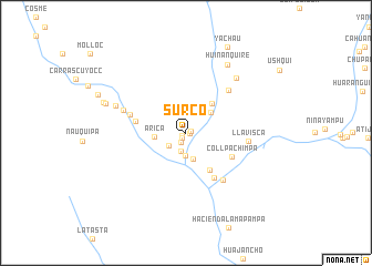
Surco (Arequipa, Peru)Surco is a town in the Arequipa region of Peru. An overview map of the region around Surco is displayed below.
regional and 3d topo map of Surco, Peru ::
Surco airports ::
The nearest airport is AQP - Arequipa Rodriguez Ballon, located 185.5 km south east of Surco.
Other airports nearby include ANS - Andahuaylas (206.1 km north), Nearby towns ::
Piñucha (0.3km east) //
Puente Grande (0.4km south west) //
Siguay (0.5km north east) //
Puglle (0.7km south west) //
Aparej (1.1km south west) //
Baulihausi (1.9km south) //
Guante (2.1km south west) //
San Felipe (2.3km south) //
Porvenir (2.7km south) //
Arica (3.1km west) //
Barracoa (3.2km north east) //
Sicuayoj (3.9km north east) //
Chaucalla (4.3km south east) //
Quimsa Cruz (5.0km west) //
Collpa Chimpa (5.0km south east) //
Quiñacca (5.3km south east) //
Pampa Blanca (5.7km west) //
Llaico (5.9km south east) //
Macetinya (6.0km north east) //
Llavisca (6.2km east) //
Pan de Azúcar (6.5km west) //
Llavepampa (7.4km north east) //
Cocharca (7.4km west) //
Huiñanquire (8.0km north east) //
Maran (8.3km west) //
Huachag (8.6km west) //
Yachau (9.6km north east) //
[all distances 'as the bird flies' and approximate] 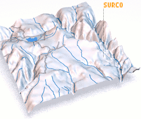 Places with similar names to Surco, Peru ::
Disclaimer :: Information on this page comes without warranty of any kind |
||
|
Where is Surco? Elevation and coordinates ::
Latitude (lat): 15°33'17"S Longitude (lon): 73°6'49"W
Elevation (approx.): 956m (map arrows pan, magnifying glasses zoom) |
||
|
Visiting Surco? Hotel/Accommodation ::
Book a hotel in Surco Travel Guide ::
Buy a travel guide for Peru rental cars ::
car rental offers GPS waypoint ::
download a GPX waypoint (PoI) of Surco for your GPS receiver
|
||