|
search place name
|
||
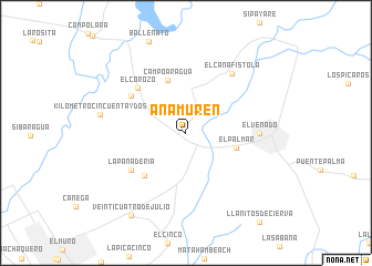
Anamuren (Zulia, Venezuela)Anamuren is a town in the Zulia region of Venezuela. An overview map of the region around Anamuren is displayed below.
regional and 3d topo map of Anamuren, Venezuela ::
Anamuren airports ::
The nearest airport is VLV - Valera Dr Antonio Nicolas Briceno, located 94.0 km south east of Anamuren.
Other airports nearby include MAR - Maracaibo La Chinita Intl (95.5 km north west), STB - Santa Barbara Del Zulia (160.5 km south west), MRD - Merida Alberto Carnevalli (167.0 km south), GUQ - Guanare (179.8 km south east), Nearby towns ::
El Palmar (5.3km east) //
Campo Aragua (5.6km north) //
Sabana de Machango (5.9km south west) //
El Corozo (6.6km north west) //
La Panadería (6.6km south west) //
Corocito (6.6km north west) //
El Venado (7.3km east) //
El Cañafistola (7.5km north east) //
Kilómetro Cincuenta y Dos (8.7km west) //
Veinticuatro de Julio (10.0km south west) //
[all distances 'as the bird flies' and approximate] 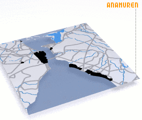 Places with similar names to Anamuren, Venezuela ::
// Anamrane (MA)
// Anamborano (MG)
// Anamborano (MG)
// Anamboriana (MG)
// Anamboriana (MG)
// Aniamarina (MG)
// ʼAïn Merane (DZ)
Disclaimer :: Information on this page comes without warranty of any kind |
||
|
Where is Anamuren? Elevation and coordinates ::
Latitude (lat): 10°5'0"N Longitude (lon): 71°0'0"W
Elevation (approx.): 68m (map arrows pan, magnifying glasses zoom) |
||
|
Visiting Anamuren? Hotel/Accommodation ::
Book a hotel in Anamuren Travel Guide ::
Buy a travel guide for Venezuela rental cars ::
car rental offers GPS waypoint ::
download a GPX waypoint (PoI) of Anamuren for your GPS receiver
|
||