|
search place name
|
||
Barro Negro (Barinas, Venezuela)Barro Negro is a town in the Barinas region of Venezuela. An overview map of the region around Barro Negro is displayed below.
regional and 3d topo map of Barro Negro, Venezuela ::

Barro Negro airports ::
The nearest airport is AUC - Arauca Santiago Perez, located 89.6 km south east of Barro Negro.
Other airports nearby include MRD - Merida Alberto Carnevalli (90.2 km north), STD - Santo Domingo Mayor Buenaventura Vivas (100.2 km west), LFR - La Fria (134.2 km north west), BNS - Barinas (139.2 km north east), Nearby towns ::
La Quebrada (2.6km north west) //
La Queveda (3.2km north west) //
San José (5.3km north) //
La Galera (5.3km north) //
Santa Bárbara (6.3km north west) //
El Socorro (7.6km west) //
El Cerrito (8.2km north west) //
El Paso (8.3km south east) //
Camachero (8.4km south east) //
Suripá (8.5km west) //
Pedernales (8.8km north west) //
La Luisa (9.2km north east) //
[all distances 'as the bird flies' and approximate] 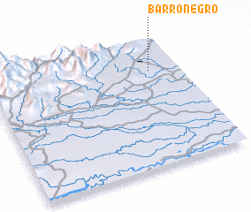 Places with similar names to Barro Negro, Venezuela ::
// Bronnacker (DE)
// Branqueira (PT)
// Barro Negro (BO)
// Berenguer (CU)
// Borangar (UA)
// Barānqār (IR)
// Brinegar (US)
// Brinker (US)
// Bernecker (US)
// Brinker (US)
Disclaimer :: Information on this page comes without warranty of any kind |
||
|
Where is Barro Negro? Elevation and coordinates ::
Latitude (lat): 7°46'0"N Longitude (lon): 71°9'0"W
Elevation (approx.): 159m (map arrows pan, magnifying glasses zoom) |
||
|
Visiting Barro Negro? Hotel/Accommodation ::
Book a hotel in Barro Negro Travel Guide ::
Buy a travel guide for Venezuela rental cars ::
car rental offers GPS waypoint ::
download a GPX waypoint (PoI) of Barro Negro for your GPS receiver
|
||