|
search place name
|
||
Buenos Aires (Monagas, Venezuela)Buenos Aires is a town in the Monagas region of Venezuela. An overview map of the region around Buenos Aires is displayed below.
regional and 3d topo map of Buenos Aires, Venezuela ::

Buenos Aires airports ::
The nearest airport is CUP - Carupano General Jose Francisco Bermudez, located 51.7 km north of Buenos Aires.
Other airports nearby include MUN - Maturin (55.2 km south east), CUM - Cumana Antonio Jose De Sucre (88.5 km west), PMV - Porlamar Del Caribe Intl Gen Santiago Marino (102.7 km north west), GUI - Guiria (122.0 km east), Nearby towns ::
El Algarrobo (2.7km west) //
El Aguacate (2.9km west) //
Sabana del Aguacate (4.8km west) //
Mesa Bonita (5.3km south) //
Pajaral (5.3km east) //
Yucucual (6.4km south west) //
Piedra de Moler (6.5km west) //
Quebrada de Agua (6.6km west) //
Cacahual (6.8km west) //
Quebrada Grande (8.3km west) //
Colorado (8.4km west) //
Juajillal (8.9km north) //
El Palmar (10.9km north west) //
[all distances 'as the bird flies' and approximate] 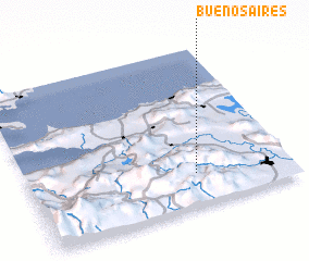 Places with similar names to Buenos Aires, Venezuela ::
// Buenos Aires (PH)
// Buenos Aires (PH)
// Buenos Aires (PH)
// Buenos Aires (PH)
// Buenos Aires (PH)
// Buenos-Aires (PH)
// Buenos Aires (US)
// Buenos Aires (PA)
// Buenos Aires (PA)
// Buenos Aires (PA)
Disclaimer :: Information on this page comes without warranty of any kind |
||
|
Where is Buenos Aires? Elevation and coordinates ::
Latitude (lat): 10°12'13"N Longitude (lon): 63°21'43"W
Elevation (approx.): 824m (map arrows pan, magnifying glasses zoom) |
||
|
Visiting Buenos Aires? Hotel/Accommodation ::
Book a hotel in Buenos Aires Travel Guide ::
Buy a travel guide for Venezuela rental cars ::
car rental offers GPS waypoint ::
download a GPX waypoint (PoI) of Buenos Aires for your GPS receiver
|
||