|
search place name
|
||
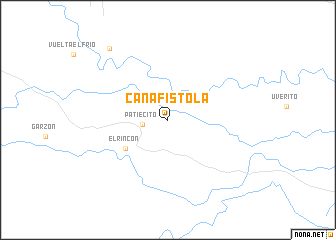
Cañafistola (Portuguesa, Venezuela)Cañafistola is a town in the Portuguesa region of Venezuela. An overview map of the region around Cañafistola is displayed below.
regional and 3d topo map of Cañafistola, Venezuela ::
Cañafistola airports ::
The nearest airport is AGV - Acarigua Oswaldo Guevara Mujica, located 92.9 km north west of Cañafistola.
Other airports nearby include GUQ - Guanare (103.4 km west), BRM - Barquisimeto Intl (147.6 km north west), BNS - Barinas (153.4 km west), SFH - San Felipe Sub Teniente Nestor Arias (162.5 km north), Nearby towns ::
Patiecito (2.9km west) //
El Rincón (5.6km south west) //
Rompia del Zamuro (10.3km north west) //
[all distances 'as the bird flies' and approximate] 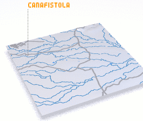 Places with similar names to Cañafistola, Venezuela ::
// Cañafístulo (PA)
// Cañafístola (CO)
// Cañafístola (CO)
// Cañafístula (CO)
// Cañafístula (CR)
// Cañafístula (CR)
// Cañafístula (SV)
// Cañafístula (SV)
// Canafistola (VE)
// Cañafistola (VE)
Disclaimer :: Information on this page comes without warranty of any kind |
||
|
Where is Cañafistola? Elevation and coordinates ::
Latitude (lat): 8°48'42"N Longitude (lon): 68°50'24"W
Elevation (approx.): 80m (map arrows pan, magnifying glasses zoom) |
||
|
Visiting Cañafistola? Hotel/Accommodation ::
Book a hotel in Cañafistola Travel Guide ::
Buy a travel guide for Venezuela rental cars ::
car rental offers GPS waypoint ::
download a GPX waypoint (PoI) of Cañafistola for your GPS receiver
|
||