|
search place name
|
||
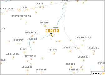
Capita (Carabobo, Venezuela)Capita is a town in the Carabobo region of Venezuela. An overview map of the region around Capita is displayed below.
regional and 3d topo map of Capita, Venezuela ::
Capita airports ::
The nearest airport is PBL - Puerto Cabello General Bartolome Salom Intl, located 34.8 km north east of Capita.
Other airports nearby include SFH - San Felipe Sub Teniente Nestor Arias (43.9 km west), VLN - Valencia Arturo Michelena Intl (52.1 km south east), BRM - Barquisimeto Intl (114.4 km west), AGV - Acarigua Oswaldo Guevara Mujica (130.2 km south west), Nearby towns ::
Canoabo (1.9km south east) //
La Isla (2.5km north east) //
Anselmito (2.8km south east) //
El Roble (4.9km north west) //
Riecito (5.7km south) //
La Sabana (6.4km east) //
Bucaral (6.8km west) //
El Escondido (7.2km west) //
Las Garcitas (7.9km south east) //
Roncadores (8.2km south west) //
Santa Rosa (10.9km south west) //
[all distances 'as the bird flies' and approximate] 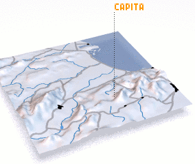 Places with similar names to Capita, Venezuela ::
Disclaimer :: Information on this page comes without warranty of any kind |
||
|
Where is Capita? Elevation and coordinates ::
Latitude (lat): 10°20'48"N Longitude (lon): 68°21'37"W
Elevation (approx.): 272m (map arrows pan, magnifying glasses zoom) |
||
|
Visiting Capita? Hotel/Accommodation ::
Book a hotel in Capita Travel Guide ::
Buy a travel guide for Venezuela rental cars ::
car rental offers GPS waypoint ::
download a GPX waypoint (PoI) of Capita for your GPS receiver
|
||