|
search place name
|
||
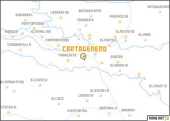
Cartagenero (Barinas, Venezuela)Cartagenero is a town in the Barinas region of Venezuela. An overview map of the region around Cartagenero is displayed below.
regional and 3d topo map of Cartagenero, Venezuela ::
Cartagenero airports ::
The nearest airport is AUC - Arauca Santiago Perez, located 78.2 km south east of Cartagenero.
Other airports nearby include STD - Santo Domingo Mayor Buenaventura Vivas (78.7 km west), TME - Tame (120.5 km south west), MRD - Merida Alberto Carnevalli (126.3 km north), SVZ - San Antonio Del Tachira (129.6 km west), Nearby towns ::
Banco las Piñas (2.6km north east) //
Santa Cruz de Guaca (3.6km east) //
Trapichito (3.7km west) //
Bocas Las Doradas (3.8km north east) //
Las Parcelas (3.8km north west) //
La Ceibita (5.0km north) //
Serranero (5.1km north) //
Romereño (5.8km north) //
Los Canitos (6.3km north) //
El Cantón (6.3km north east) //
Campo Barinas (6.8km north west) //
La Espuma (7.0km north) //
Guacas (7.1km east) //
Tomasero (7.8km north) //
El Rosario (7.9km east) //
El Jilguero (8.3km north east) //
El Escoplo (8.4km south east) //
La Monita (8.9km south) //
Paso el Potrero (9.9km north east) //
Pedraceño (11.5km north east) //
[all distances 'as the bird flies' and approximate]  Places with similar names to Cartagenero, Venezuela :: Disclaimer :: Information on this page comes without warranty of any kind |
||
|
Where is Cartagenero? Elevation and coordinates ::
Latitude (lat): 7°27'10"N Longitude (lon): 71°19'52"W
Elevation (approx.): 157m (map arrows pan, magnifying glasses zoom) |
||
|
Visiting Cartagenero? Hotel/Accommodation ::
Book a hotel in Cartagenero Travel Guide ::
Buy a travel guide for Venezuela rental cars ::
car rental offers GPS waypoint ::
download a GPX waypoint (PoI) of Cartagenero for your GPS receiver
|
||