|
search place name
|
||
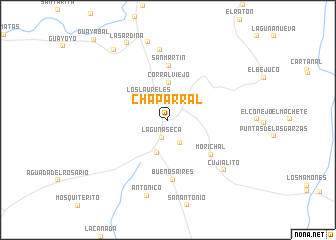
Chaparral (Guárico, Venezuela)Chaparral is a town in the Guárico region of Venezuela. An overview map of the region around Chaparral is displayed below.
regional and 3d topo map of Chaparral, Venezuela ::
Chaparral airports ::
The nearest airport is VDP - Valle De La Pascua, located 113.1 km east of Chaparral.
Other airports nearby include VLN - Valencia Arturo Michelena Intl (140.7 km north west), CCS - Caracas Simon Bolivar Intl (149.8 km north), SFD - San Fernando De Apure (158.0 km south), PBL - Puerto Cabello General Bartolome Salom Intl (178.4 km north west), Nearby towns ::
Laguna Seca (2.1km south) //
La Vaquira (2.9km south east) //
Los Laureles (3.3km north west) //
La Encrucijada (3.8km south) //
Corral Viejo (4.1km north) //
San Martin (6.1km north) //
Morichal (6.1km south east) //
Buenos Aires (6.7km south) //
El Algarrobo (7.9km north) //
Cujialito (8.3km south east) //
Antoñico (8.8km south) //
La Lucha (9.0km north) //
La Sardina (9.7km north west) //
La Carita (9.8km north west) //
[all distances 'as the bird flies' and approximate] 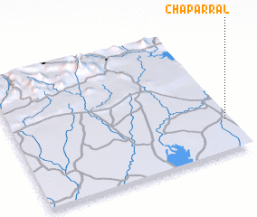 Places with similar names to Chaparral, Venezuela ::
Disclaimer :: Information on this page comes without warranty of any kind |
||
|
Where is Chaparral? Elevation and coordinates ::
Latitude (lat): 9°14'58"N Longitude (lon): 67°1'22"W
Elevation (approx.): 230m (map arrows pan, magnifying glasses zoom) |
||
|
Visiting Chaparral? Hotel/Accommodation ::
Book a hotel in Chaparral Travel Guide ::
Buy a travel guide for Venezuela rental cars ::
car rental offers GPS waypoint ::
download a GPX waypoint (PoI) of Chaparral for your GPS receiver
|
||