|
search place name
|
||
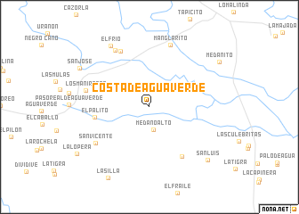
Costa de Agua Verde (Guárico, Venezuela)Costa de Agua Verde is a town in the Guárico region of Venezuela. An overview map of the region around Costa de Agua Verde is displayed below.
regional and 3d topo map of Costa de Agua Verde, Venezuela ::
Costa de Agua Verde airports ::
The nearest airport is SFD - San Fernando De Apure, located 41.0 km west of Costa de Agua Verde.
Other airports nearby include VDP - Valle De La Pascua (187.1 km north east), PCR - Puerto Carreno (196.9 km south), Nearby towns ::
Médano Alto (2.9km south) //
El Palito (7.0km west) //
La Laguna (7.4km south east) //
La Morita (7.9km north west) //
San Vicente (8.1km south west) //
Manglarito (8.2km north) //
Los Manirotes (8.2km west) //
La Monta (8.3km north west) //
El Frío (9.0km north west) //
San Luis (9.9km south east) //
San José (10.0km north west) //
La Silla (10.3km south west) //
Medanito (10.3km north east) //
[all distances 'as the bird flies' and approximate] 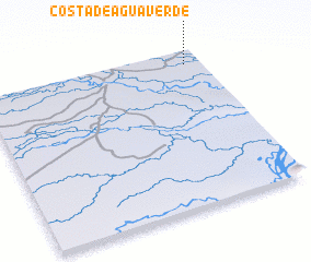 Places with similar names to Costa de Agua Verde, Venezuela :: Disclaimer :: Information on this page comes without warranty of any kind |
||
|
Where is Costa de Agua Verde? Elevation and coordinates ::
Latitude (lat): 7°54'54"N Longitude (lon): 67°4'24"W
Elevation (approx.): 41m (map arrows pan, magnifying glasses zoom) |
||
|
Visiting Costa de Agua Verde? Hotel/Accommodation ::
Book a hotel in Costa de Agua Verde Travel Guide ::
Buy a travel guide for Venezuela rental cars ::
car rental offers GPS waypoint ::
download a GPX waypoint (PoI) of Costa de Agua Verde for your GPS receiver
|
||