|
search place name
|
||
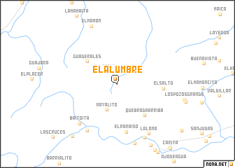
El Alumbre (Falcón, Venezuela)El Alumbre is a town in the Falcón region of Venezuela. An overview map of the region around El Alumbre is displayed below.
regional and 3d topo map of El Alumbre, Venezuela ::
El Alumbre airports ::
The nearest airport is CZE - Coro Jose Leonardo Chirinos, located 92.6 km north east of El Alumbre.
Other airports nearby include BRM - Barquisimeto Intl (103.6 km south east), LSP - Paraguana Josefa Camejo (123.6 km north), SFH - San Felipe Sub Teniente Nestor Arias (149.5 km east), AGV - Acarigua Oswaldo Guevara Mujica (152.9 km south east), Nearby towns ::
La Raya (2.5km north west) //
Mayalito (4.5km south) //
Guaderales (5.9km north west) //
Quebrada Arriba (6.7km south east) //
El Salto (7.3km east) //
El Paraíso (7.8km south) //
Baitoita (8.7km south west) //
El Jobito (8.8km south west) //
La Loma (9.4km south east) //
Limoncito (9.7km south east) //
El Paso (11.0km south west) //
[all distances 'as the bird flies' and approximate] 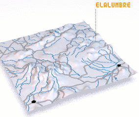 Places with similar names to El Alumbre, Venezuela ::
// El Alambre (SV)
// El Alambre (MX)
// El Alambre (VE)
// El Alambre (VE)
// El Alambre (VE)
// El Alambre (VE)
// El Alambre (VE)
Disclaimer :: Information on this page comes without warranty of any kind |
||
|
Where is El Alumbre? Elevation and coordinates ::
Latitude (lat): 10°40'2"N Longitude (lon): 70°3'48"W
Elevation (approx.): 720m (map arrows pan, magnifying glasses zoom) |
||
|
Visiting El Alumbre? Hotel/Accommodation ::
Book a hotel in El Alumbre Travel Guide ::
Buy a travel guide for Venezuela rental cars ::
car rental offers GPS waypoint ::
download a GPX waypoint (PoI) of El Alumbre for your GPS receiver
|
||