|
search place name
|
||
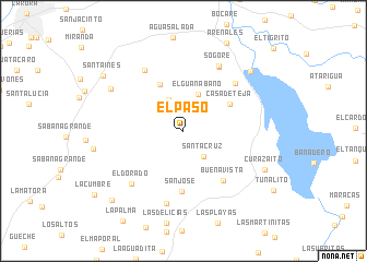
El Paso (Lara, Venezuela)El Paso is a town in the Lara region of Venezuela. An overview map of the region around El Paso is displayed below.
regional and 3d topo map of El Paso, Venezuela ::
El Paso airports ::
The nearest airport is BRM - Barquisimeto Intl, located 63.5 km east of El Paso.
Other airports nearby include AGV - Acarigua Oswaldo Guevara Mujica (95.6 km south east), VLV - Valera Dr Antonio Nicolas Briceno (107.4 km south west), GUQ - Guanare (117.0 km south), SFH - San Felipe Sub Teniente Nestor Arias (131.5 km east), Nearby towns ::
Santa Cruz (3.3km south east) //
Curuca (3.5km north west) //
El Guanábano (4.0km north) //
Guayamure (5.3km north west) //
Casa de Teja (5.4km north east) //
San José (6.2km south) //
Buena Vista (6.5km south east) //
El Tanquito (7.1km north east) //
Balsamito (7.3km north west) //
Báez (7.4km north east) //
Sogore (7.5km north east) //
La Rinconada (7.6km south) //
El Dorado (7.6km south west) //
Los Indios (8.5km north west) //
Las Veritas (9.1km north east) //
Curazaíto (9.1km south east) //
Santa Inés (9.9km north west) //
Las Piñuelas (10.1km south west) //
[all distances 'as the bird flies' and approximate] 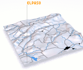 Places with similar names to El Paso, Venezuela ::
Disclaimer :: Information on this page comes without warranty of any kind |
||
|
Where is El Paso? Elevation and coordinates ::
Latitude (lat): 10°4'10"N Longitude (lon): 69°56'13"W
Elevation (approx.): 578m (map arrows pan, magnifying glasses zoom) |
||
|
Visiting El Paso? Hotel/Accommodation ::
Book a hotel in El Paso Travel Guide ::
Buy a travel guide for Venezuela rental cars ::
car rental offers GPS waypoint ::
download a GPX waypoint (PoI) of El Paso for your GPS receiver
|
||