|
search place name
|
||
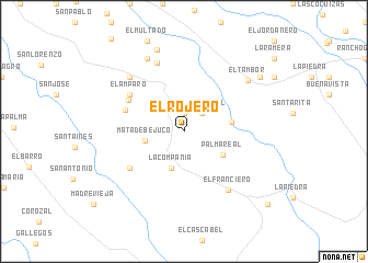
El Rojero (Barinas, Venezuela)El Rojero is a town in the Barinas region of Venezuela. An overview map of the region around El Rojero is displayed below.
regional and 3d topo map of El Rojero, Venezuela ::
El Rojero airports ::
The nearest airport is BNS - Barinas, located 59.4 km north west of El Rojero.
Other airports nearby include GUQ - Guanare (82.4 km north), VLV - Valera Dr Antonio Nicolas Briceno (145.3 km north west), AGV - Acarigua Oswaldo Guevara Mujica (153.5 km north east), MRD - Merida Alberto Carnevalli (153.5 km west), Nearby towns ::
El Morrocoy (1.9km north) //
La Palma Real (2.6km north east) //
La Compañía (3.9km south) //
Mata de Bejuco (4.1km west) //
Palma Real (4.6km south east) //
Cachaza (5.0km east) //
Guafita (6.3km west) //
Hurtado Abajo (6.4km north west) //
El Morrocoy (6.6km south west) //
El Amparo (6.6km north west) //
Potrerito (7.5km north) //
El Franciero (7.5km south east) //
La Providencia (7.8km north west) //
San José (8.3km north west) //
El Tambor (8.3km north east) //
La Gloria (8.8km north) //
Chinchorro (9.4km north east) //
Corozalito (11.2km south east) //
[all distances 'as the bird flies' and approximate] 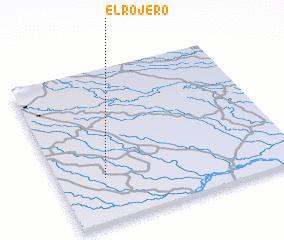 Places with similar names to El Rojero, Venezuela :: Disclaimer :: Information on this page comes without warranty of any kind |
||
|
Where is El Rojero? Elevation and coordinates ::
Latitude (lat): 8°17'0"N Longitude (lon): 69°48'0"W
Elevation (approx.): 110m (map arrows pan, magnifying glasses zoom) |
||
|
Visiting El Rojero? Hotel/Accommodation ::
Book a hotel in El Rojero Travel Guide ::
Buy a travel guide for Venezuela rental cars ::
car rental offers GPS waypoint ::
download a GPX waypoint (PoI) of El Rojero for your GPS receiver
|
||