|
search place name
|
||
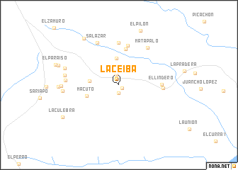
La Ceiba (Anzoátegui, Venezuela)La Ceiba is a town in the Anzoátegui region of Venezuela. An overview map of the region around La Ceiba is displayed below.
regional and 3d topo map of La Ceiba, Venezuela ::
La Ceiba airports ::
The nearest airport is SOM - San Tome, located 111.9 km north east of La Ceiba.
Other airports nearby include CBL - Ciudad Bolivar (129.6 km east), AAO - Anaco (149.3 km north), VDP - Valle De La Pascua (187.6 km north west), PZO - Guayana General Manuel Carlos Piar (216.2 km east), Nearby towns ::
El Caño (0.7km south east) //
La Renca (1.2km south) //
Uverito (1.6km north) //
Terecay (4.2km north) //
El Totumo (4.6km west) //
Macuto (5.4km west) //
El Brinco (5.7km north) //
Dura Poco (6.4km north) //
La Calceta (6.6km north) //
El Lindero (6.7km east) //
La Florida (6.9km east) //
Matapalo (7.4km north east) //
Salazar (7.5km north west) //
El Zorro (8.3km west) //
El Gavilán (8.6km west) //
El Carito (8.8km west) //
El Colorado (8.8km west) //
La Rueda (9.1km north west) //
El Pilón (9.2km north) //
La Culebra (10.1km south west) //
[all distances 'as the bird flies' and approximate] 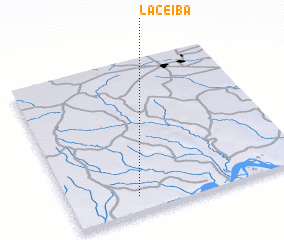 Places with similar names to La Ceiba, Venezuela ::
Disclaimer :: Information on this page comes without warranty of any kind |
||
|
Where is La Ceiba? Elevation and coordinates ::
Latitude (lat): 8°6'8"N Longitude (lon): 64°42'48"W
Elevation (approx.): 102m (map arrows pan, magnifying glasses zoom) |
||
|
Visiting La Ceiba? Hotel/Accommodation ::
Book a hotel in La Ceiba Travel Guide ::
Buy a travel guide for Venezuela rental cars ::
car rental offers GPS waypoint ::
download a GPX waypoint (PoI) of La Ceiba for your GPS receiver
|
||