|
search place name
|
||
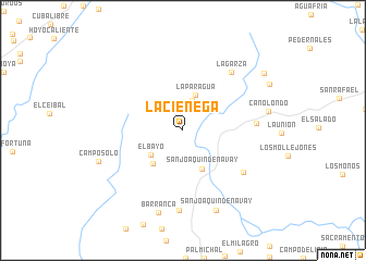
La Ciénega (Táchira, Venezuela)La Ciénega is a town in the Táchira region of Venezuela. An overview map of the region around La Ciénega is displayed below.
regional and 3d topo map of La Ciénega, Venezuela ::
La Ciénega airports ::
The nearest airport is STD - Santo Domingo Mayor Buenaventura Vivas, located 34.0 km west of La Ciénega.
Other airports nearby include SVZ - San Antonio Del Tachira (78.6 km west), LFR - La Fria (85.1 km north west), CUC - Cucuta Camilo Daza (88.9 km west), MRD - Merida Alberto Carnevalli (119.4 km north east), Nearby towns ::
La Paragua (3.2km north) //
La Paragua (3.8km north) //
El Bayo (4.1km south west) //
San Joaquín de Navay (4.5km south east) //
Los Picachos (4.6km south west) //
El Tesoro (7.5km south east) //
Agua Clara (7.5km east) //
La Garza (7.8km north east) //
San Joaquín (8.2km south) //
Barranca (8.8km south) //
San Joaquín de Navay (8.9km south) //
Caño Londo (8.9km east) //
Campo Solo (9.2km west) //
La Blanquita (10.1km north east) //
[all distances 'as the bird flies' and approximate] 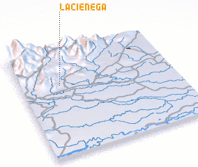 Places with similar names to La Ciénega, Venezuela ::
Disclaimer :: Information on this page comes without warranty of any kind |
||
|
Where is La Ciénega? Elevation and coordinates ::
Latitude (lat): 7°40'26"N Longitude (lon): 71°44'49"W
Elevation (approx.): 208m (map arrows pan, magnifying glasses zoom) |
||
|
Visiting La Ciénega? Hotel/Accommodation ::
Book a hotel in La Ciénega Travel Guide ::
Buy a travel guide for Venezuela rental cars ::
car rental offers GPS waypoint ::
download a GPX waypoint (PoI) of La Ciénega for your GPS receiver
|
||