|
search place name
|
||
La Concha (Falcón, Venezuela)La Concha is a town in the Falcón region of Venezuela. An overview map of the region around La Concha is displayed below.
regional and 3d topo map of La Concha, Venezuela ::
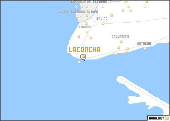
La Concha airports ::
The nearest airport is LSP - Paraguana Josefa Camejo, located 19.7 km north of La Concha.
Other airports nearby include CZE - Coro Jose Leonardo Chirinos (60.8 km east), AUA - Oranjestad Reina Beatrix Intl (100.7 km north), CUR - Willemstad Hato (149.8 km north east), BRM - Barquisimeto Intl (196.4 km south east), Nearby towns ::
La Punta (1.3km west) //
Manaure (5.2km north) //
Punta Cardón (5.5km north) //
Cardón (6.3km north) //
Tiguadare (6.9km east) //
San Ramón (7.8km east) //
Barrio Andrés Eloy Blanco (8.2km north) //
Caujarito (8.9km north east) //
Savino (9.1km north east) //
[all distances 'as the bird flies' and approximate] 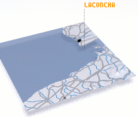 Places with similar names to La Concha, Venezuela ::
// Lokinach (ET)
// Laukinčiai (LT)
// La Concha (CU)
// La Concha (ES)
// La Concha (ES)
// La Guancha (ES)
// Lukinichi (RU)
// Licancheo (CL)
// La Quincha (CO)
// La Concha (MX)
Disclaimer :: Information on this page comes without warranty of any kind |
||
|
Where is La Concha? Elevation and coordinates ::
Latitude (lat): 11°36'36"N Longitude (lon): 70°12'10"W
Elevation (approx.): 2m (map arrows pan, magnifying glasses zoom) |
||
|
Visiting La Concha? Hotel/Accommodation ::
Book a hotel in La Concha Travel Guide ::
Buy a travel guide for Venezuela rental cars ::
car rental offers GPS waypoint ::
download a GPX waypoint (PoI) of La Concha for your GPS receiver
|
||