|
search place name
|
||
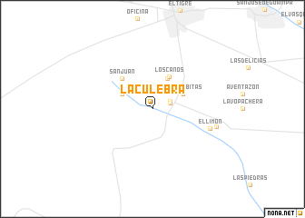
La Culebra (Anzoátegui, Venezuela)La Culebra is a town in the Anzoátegui region of Venezuela. An overview map of the region around La Culebra is displayed below.
regional and 3d topo map of La Culebra, Venezuela ::
La Culebra airports ::
The nearest airport is SOM - San Tome, located 23.1 km north east of La Culebra.
Other airports nearby include AAO - Anaco (74.5 km north), CBL - Ciudad Bolivar (110.0 km south east), BLA - Barcelona General Jose Antonio Anzoategui Intl (153.1 km north), MUN - Maturin (163.8 km north east), Nearby towns ::
El Caris (2.3km east) //
El Caris (2.3km north east) //
Las Bombitas (4.1km north east) //
Cabeceras (4.1km north east) //
El Paramadero (4.1km north west) //
Los Caños (4.4km north east) //
San Juan (5.2km north west) //
El Limón (7.4km east) //
Aventazón (8.1km east) //
[all distances 'as the bird flies' and approximate] 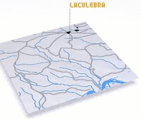 Places with similar names to La Culebra, Venezuela ::
// La Culebra (PA)
// La Culebra (PA)
// La Culebra (CO)
// La Culebra (CO)
// La Culebra (CO)
// La Culebra (CO)
// La Culebra (CO)
// Laclubar (TP)
// La Culebra (MX)
// La Culebra (MX)
Disclaimer :: Information on this page comes without warranty of any kind |
||
|
Where is La Culebra? Elevation and coordinates ::
Latitude (lat): 8°47'0"N Longitude (lon): 64°17'0"W
Elevation (approx.): 222m (map arrows pan, magnifying glasses zoom) |
||
|
Visiting La Culebra? Hotel/Accommodation ::
Book a hotel in La Culebra Travel Guide ::
Buy a travel guide for Venezuela rental cars ::
car rental offers GPS waypoint ::
download a GPX waypoint (PoI) of La Culebra for your GPS receiver
|
||