|
search place name
|
||
La Curva (Zulia, Venezuela)La Curva is a town in the Zulia region of Venezuela. An overview map of the region around La Curva is displayed below.
regional and 3d topo map of La Curva, Venezuela ::

La Curva airports ::
The nearest airport is VLV - Valera Dr Antonio Nicolas Briceno, located 52.0 km south east of La Curva.
Other airports nearby include MAR - Maracaibo La Chinita Intl (135.0 km north west), MRD - Merida Alberto Carnevalli (136.5 km south), GUQ - Guanare (140.1 km south east), BNS - Barinas (141.2 km south east), Nearby towns ::
San Juan (2.1km south east) //
San Joaquín (2.1km north west) //
La Mesa (2.6km east) //
Santa Rosa (3.3km south east) //
Las Granjas (5.8km south east) //
Río Paují (5.9km south east) //
El Encanto (6.1km east) //
San Pablo (6.2km west) //
Trujillito (7.3km south east) //
El Batatal (10.3km south west) //
El Gallo (10.4km south east) //
El Tigre (10.5km south west) //
[all distances 'as the bird flies' and approximate] 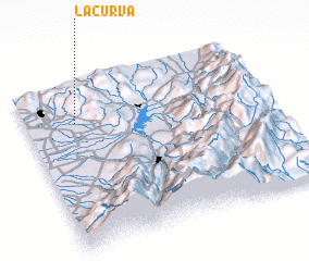 Places with similar names to La Curva, Venezuela ::
// Lagoa Ruiva (PT)
// La Curva (CU)
// Lakarevo (BG)
// La Garrofa (ES)
// Lekarevo (RU)
// Lekarevo (RU)
// La Curva (CO)
// La Curva (CO)
// La Curva (CO)
// La Curva (CO)
Disclaimer :: Information on this page comes without warranty of any kind |
||
|
Where is La Curva? Elevation and coordinates ::
Latitude (lat): 9°45'42"N Longitude (lon): 70°47'41"W
Elevation (approx.): 61m (map arrows pan, magnifying glasses zoom) |
||
|
Visiting La Curva? Hotel/Accommodation ::
Book a hotel in La Curva Travel Guide ::
Buy a travel guide for Venezuela rental cars ::
car rental offers GPS waypoint ::
download a GPX waypoint (PoI) of La Curva for your GPS receiver
|
||