|
search place name
|
||
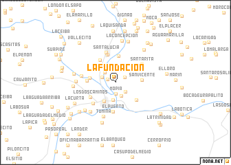
La Fundación (Miranda, Venezuela)La Fundación is a town in the Miranda region of Venezuela. An overview map of the region around La Fundación is displayed below.
regional and 3d topo map of La Fundación, Venezuela ::
La Fundación airports ::
The nearest airport is CCS - Caracas Simon Bolivar Intl, located 53.5 km north west of La Fundación.
Other airports nearby include VDP - Valle De La Pascua (135.2 km south east), VLN - Valencia Arturo Michelena Intl (140.9 km west), PBL - Puerto Cabello General Bartolome Salom Intl (158.1 km west), BLA - Barcelona General Jose Antonio Anzoategui Intl (215.2 km east), Nearby towns ::
Las Monjas (1.4km north west) //
La Virginia (1.7km north east) //
Mopia (1.9km south) //
Seúce (2.2km south east) //
Soapire (2.3km west) //
Las Plazas (2.4km north west) //
Paso Real (2.4km south east) //
La Tortuga (2.9km south) //
Santa Teresa (3.6km south west) //
San Vicente (4.2km east) //
Bachaquero (4.2km west) //
Las Adjuntas (4.4km north) //
Paso Largo (4.4km south east) //
El Volcán (4.4km north west) //
La Vega (4.6km north east) //
Bachaquero (4.6km west) //
El Hormiguero (4.7km north) //
El Puerto (4.7km south) //
Los Dos Caminos (4.7km south west) //
El Socorro (4.9km south west) //
Santa Lucía (5.1km north) //
Santa Rita (5.2km north east) //
Los Güires (5.5km west) //
Tumina (5.9km south) //
La Vencedora (6.2km south west) //
Los Guaracaros (6.4km west) //
El Hornito (6.7km south west) //
La Concepción (6.8km north) //
Cartanal (6.8km west) //
[all distances 'as the bird flies' and approximate] 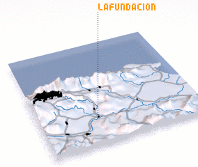 Places with similar names to La Fundación, Venezuela ::
// La Fundición (CU)
// La Fundación (CO)
// La Fundición (MX)
// La Fundición (MX)
// La Fundición (MX)
// La Fundación (VE)
// La Fundación (VE)
// La Fundación (VE)
// La Fundación (VE)
// La Fundación (VE)
Disclaimer :: Information on this page comes without warranty of any kind |
||
|
Where is La Fundación? Elevation and coordinates ::
Latitude (lat): 10°15'32"N Longitude (lon): 66°38'49"W
Elevation (approx.): 157m (map arrows pan, magnifying glasses zoom) |
||
|
Visiting La Fundación? Hotel/Accommodation ::
Book a hotel in La Fundación Travel Guide ::
Buy a travel guide for Venezuela rental cars ::
car rental offers GPS waypoint ::
download a GPX waypoint (PoI) of La Fundación for your GPS receiver
|
||