|
search place name
|
||
La Mata (Distrito Federal, Venezuela)La Mata is a town in the Distrito Federal region of Venezuela. An overview map of the region around La Mata is displayed below.
regional and 3d topo map of La Mata, Venezuela ::

La Mata airports ::
The nearest airport is CCS - Caracas Simon Bolivar Intl, located 11.6 km north east of La Mata.
Other airports nearby include VLN - Valencia Arturo Michelena Intl (104.4 km south west), PBL - Puerto Cabello General Bartolome Salom Intl (112.1 km west), VDP - Valle De La Pascua (184.2 km south east), SFH - San Felipe Sub Teniente Nestor Arias (188.6 km west), Nearby towns ::
La Matica (0.9km south west) //
El Banqueo (1.5km north east) //
La Fundación (1.9km north) //
La Fábrica (1.8km west) //
La Montaña (2.6km north west) //
Farfán (2.6km north west) //
La Rochela (3.3km south west) //
La Julia (3.6km west) //
La Mata (3.6km west) //
Sabanetica (3.7km south) //
Subida de Los Cielos (3.7km north east) //
El Topo (3.7km west) //
Urbanización El Junco (3.8km south) //
Yaguara (4.1km north west) //
Fatriquera (4.1km south west) //
Sabaneta (4.1km south east) //
Sagüino (4.1km south east) //
Planta de Mamo (4.2km north west) //
Dos Caminos (4.6km north east) //
Tasajera (5.2km east) //
Salto Boquerón (5.3km north east) //
El Encantado (5.4km south west) //
Cataure (5.5km west) //
La Luz (5.5km west) //
El Pozo (6.1km north west) //
Vallenilla (6.6km north east) //
Valle Hondo (6.6km north west) //
El Junquito (6.6km south west) //
Cortada Guamacho (6.6km north west) //
[all distances 'as the bird flies' and approximate] 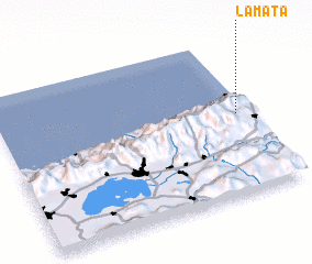 Places with similar names to La Mata, Venezuela ::
Disclaimer :: Information on this page comes without warranty of any kind |
||
|
Where is La Mata? Elevation and coordinates ::
Latitude (lat): 10°31'0"N Longitude (lon): 67°3'0"W
Elevation (approx.): 984m (map arrows pan, magnifying glasses zoom) |
||
|
Visiting La Mata? Hotel/Accommodation ::
Book a hotel in La Mata Travel Guide ::
Buy a travel guide for Venezuela rental cars ::
car rental offers GPS waypoint ::
download a GPX waypoint (PoI) of La Mata for your GPS receiver
|
||