|
search place name
|
||
Las Sardinas (Anzoátegui, Venezuela)Las Sardinas is a town in the Anzoátegui region of Venezuela. An overview map of the region around Las Sardinas is displayed below.
regional and 3d topo map of Las Sardinas, Venezuela ::

Las Sardinas airports ::
The nearest airport is SOM - San Tome, located 100.5 km north of Las Sardinas.
Other airports nearby include CBL - Ciudad Bolivar (101.2 km east), AAO - Anaco (148.5 km north), PZO - Guayana General Manuel Carlos Piar (188.0 km east), VDP - Valle De La Pascua (210.8 km north west), Nearby towns ::
La Orilla (3.6km south) //
Santa Cruz de Orinoco (3.6km south) //
La Vega (5.1km south east) //
Los Cochinos (5.9km south east) //
Mahomito (6.9km south west) //
Zanjonalito (7.6km west) //
El Bote (8.5km south east) //
El Alto (9.1km west) //
Guaicupa (9.2km north east) //
[all distances 'as the bird flies' and approximate] 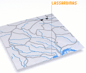 Places with similar names to Las Sardinas, Venezuela ::
// Las Sardinas (PA)
// Las Sardinas (MX)
// Las Sardinas (VE)
// Las Sardinas (VE)
// Los Ratones (HT)
// Los Ratones (HT)
// Les Roudons (FR)
Disclaimer :: Information on this page comes without warranty of any kind |
||
|
Where is Las Sardinas? Elevation and coordinates ::
Latitude (lat): 8°5'16"N Longitude (lon): 64°27'17"W
Elevation (approx.): 82m (map arrows pan, magnifying glasses zoom) |
||
|
Visiting Las Sardinas? Hotel/Accommodation ::
Book a hotel in Las Sardinas Travel Guide ::
Buy a travel guide for Venezuela rental cars ::
car rental offers GPS waypoint ::
download a GPX waypoint (PoI) of Las Sardinas for your GPS receiver
|
||