|
search place name
|
||
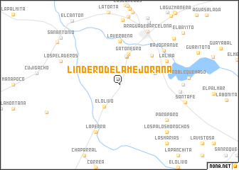
Lindero de la Mejorana (Anzoátegui, Venezuela)Lindero de la Mejorana is a town in the Anzoátegui region of Venezuela. An overview map of the region around Lindero de la Mejorana is displayed below.
regional and 3d topo map of Lindero de la Mejorana, Venezuela ::
Lindero de la Mejorana airports ::
The nearest airport is AAO - Anaco, located 43.8 km east of Lindero de la Mejorana.
Other airports nearby include BLA - Barcelona General Jose Antonio Anzoategui Intl (82.4 km north), SOM - San Tome (92.4 km south east), VDP - Valle De La Pascua (125.1 km west), CUM - Cumana Antonio Jose De Sucre (143.0 km north east), Nearby towns ::
El Olivo (4.1km south west) //
La Platera (4.5km north) //
La Platera (4.6km north) //
Gato Negro (5.1km north) //
Lázaro (5.8km east) //
La Verbena (6.8km north) //
Ventorrillo (6.9km north east) //
La Perra (8.3km south west) //
La Lira (8.2km north east) //
Bajo Grande (8.7km north east) //
Paraparo (9.2km south east) //
Aragua de Barcelona (9.5km north east) //
Los Palos Morochos (10.4km south east) //
El Bayito (11.2km north east) //
[all distances 'as the bird flies' and approximate]  Places with similar names to Lindero de la Mejorana, Venezuela :: Disclaimer :: Information on this page comes without warranty of any kind |
||
|
Where is Lindero de la Mejorana? Elevation and coordinates ::
Latitude (lat): 9°23'0"N Longitude (lon): 64°52'0"W
Elevation (approx.): 106m (map arrows pan, magnifying glasses zoom) |
||
|
Visiting Lindero de la Mejorana? Hotel/Accommodation ::
Book a hotel in Lindero de la Mejorana Travel Guide ::
Buy a travel guide for Venezuela rental cars ::
car rental offers GPS waypoint ::
download a GPX waypoint (PoI) of Lindero de la Mejorana for your GPS receiver
|
||