|
search place name
|
||
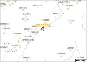
Maporal (Táchira, Venezuela)Maporal is a town in the Táchira region of Venezuela. An overview map of the region around Maporal is displayed below.
regional and 3d topo map of Maporal, Venezuela ::
Maporal airports ::
The nearest airport is STD - Santo Domingo Mayor Buenaventura Vivas, located 36.4 km south west of Maporal.
Other airports nearby include SVZ - San Antonio Del Tachira (70.0 km west), LFR - La Fria (70.5 km north west), CUC - Cucuta Camilo Daza (79.0 km west), MRD - Merida Alberto Carnevalli (111.8 km north east), Nearby towns ::
La Hormiga (2.6km north) //
Santa Cruz (2.7km south west) //
Paramito (3.4km west) //
San Rafael (3.6km north) //
El Reverendo (3.6km north east) //
Las Talas (3.8km west) //
El Sarare (3.9km north) //
Saladito (3.9km west) //
El Estoraque (4.8km north east) //
La Fundación (5.7km west) //
Las Mesas (6.5km west) //
Cuba Libre (7.6km south west) //
Las Guasduas (7.8km north east) //
Hoyo Caliente (8.1km south west) //
Río Azul (8.9km north west) //
Los Altillos (9.2km north east) //
Los Leónes (9.8km north west) //
[all distances 'as the bird flies' and approximate] 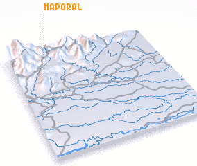 Places with similar names to Maporal, Venezuela ::
Disclaimer :: Information on this page comes without warranty of any kind |
||
|
Where is Maporal? Elevation and coordinates ::
Latitude (lat): 7°48'6"N Longitude (lon): 71°48'22"W
Elevation (approx.): 946m (map arrows pan, magnifying glasses zoom) |
||
|
Visiting Maporal? Hotel/Accommodation ::
Book a hotel in Maporal Travel Guide ::
Buy a travel guide for Venezuela rental cars ::
car rental offers GPS waypoint ::
download a GPX waypoint (PoI) of Maporal for your GPS receiver
|
||