|
search place name
|
||
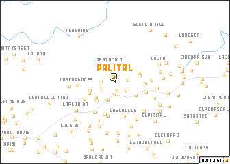
Palital (Falcón, Venezuela)Palital is a town in the Falcón region of Venezuela. An overview map of the region around Palital is displayed below.
regional and 3d topo map of Palital, Venezuela ::
Palital airports ::
The nearest airport is CZE - Coro Jose Leonardo Chirinos, located 77.2 km north west of Palital.
Other airports nearby include SFH - San Felipe Sub Teniente Nestor Arias (84.3 km south east), BRM - Barquisimeto Intl (91.9 km south), PBL - Puerto Cabello General Bartolome Salom Intl (135.2 km east), LSP - Paraguana Josefa Camejo (141.5 km north west), Nearby towns ::
Agua Dulce (1.3km south) //
Areguito (2.0km south) //
Mamá Flor (2.0km east) //
El Mirador (2.1km south east) //
Ojo de Agua (2.3km west) //
El Silencio (2.4km south west) //
La Estación (2.8km north) //
La Danta (3.1km south west) //
San Gabriel (3.9km south east) //
Clavelito (4.0km south west) //
EL Saltico (4.1km east) //
Barrio El Pajón (4.2km south west) //
Ciénega Amarilla (4.3km west) //
El Saltigo (4.3km east) //
Ciénaga Amarilla (4.5km south west) //
Cabeza de Toro (4.8km east) //
El Charal (5.1km east) //
Jibillal (5.5km south) //
Jabillal (5.5km south) //
La Sabana (5.6km south west) //
Los Chucos (5.8km south) //
El Torito (5.8km east) //
Santa Cruz de Bucaral (5.9km south west) //
Los Cardones (6.1km west) //
Las Margaritas (6.6km south east) //
Guarataro (6.7km south) //
Cantarrana (6.7km east) //
Las Cumbres (6.8km south east) //
Carpa (6.9km south east) //
[all distances 'as the bird flies' and approximate]  Places with similar names to Palital, Venezuela ::
Disclaimer :: Information on this page comes without warranty of any kind |
||
|
Where is Palital? Elevation and coordinates ::
Latitude (lat): 10°51'57"N Longitude (lon): 69°14'45"W
Elevation (approx.): 928m (map arrows pan, magnifying glasses zoom) |
||
|
Visiting Palital? Hotel/Accommodation ::
Book a hotel in Palital Travel Guide ::
Buy a travel guide for Venezuela rental cars ::
car rental offers GPS waypoint ::
download a GPX waypoint (PoI) of Palital for your GPS receiver
|
||