|
search place name
|
||
Paso de San Antonio (Barinas, Venezuela)Paso de San Antonio is a town in the Barinas region of Venezuela. An overview map of the region around Paso de San Antonio is displayed below.
regional and 3d topo map of Paso de San Antonio, Venezuela ::

Paso de San Antonio airports ::
The nearest airport is SFD - San Fernando De Apure, located 135.0 km east of Paso de San Antonio.
Other airports nearby include GUQ - Guanare (169.0 km north west), BNS - Barinas (186.5 km north west), AGV - Acarigua Oswaldo Guevara Mujica (188.1 km north), PCR - Puerto Carreno (234.3 km south east), Nearby towns ::
Santo Cristo (4.1km south west) //
El Paso de Guamo (5.4km south west) //
El Guayabo (5.6km south) //
San Antonio (5.9km north) //
Las Flores (6.6km north west) //
Bancote (6.8km south west) //
Banco Largo (7.3km east) //
Barba de Tigre (7.6km west) //
Macanillal (7.6km south) //
El Samán de Apure (8.2km south west) //
La Bolivera (9.2km south west) //
[all distances 'as the bird flies' and approximate] 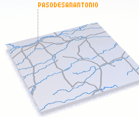 Places with similar names to Paso de San Antonio, Venezuela ::
// Paso de San Antonio (MX)
// Paso de San Antonio (MX)
Disclaimer :: Information on this page comes without warranty of any kind |
||
|
Where is Paso de San Antonio? Elevation and coordinates ::
Latitude (lat): 7°57'0"N Longitude (lon): 68°40'0"W
Elevation (approx.): 75m (map arrows pan, magnifying glasses zoom) |
||
|
Visiting Paso de San Antonio? Hotel/Accommodation ::
Book a hotel in Paso de San Antonio Travel Guide ::
Buy a travel guide for Venezuela rental cars ::
car rental offers GPS waypoint ::
download a GPX waypoint (PoI) of Paso de San Antonio for your GPS receiver
|
||