|
search place name
|
||
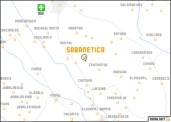
Sabanetica (Portuguesa, Venezuela)Sabanetica is a town in the Portuguesa region of Venezuela. An overview map of the region around Sabanetica is displayed below.
regional and 3d topo map of Sabanetica, Venezuela ::
Sabanetica airports ::
The nearest airport is AGV - Acarigua Oswaldo Guevara Mujica, located 15.0 km north west of Sabanetica.
Other airports nearby include BRM - Barquisimeto Intl (69.6 km north), GUQ - Guanare (81.1 km south west), SFH - San Felipe Sub Teniente Nestor Arias (101.6 km north east), BNS - Barinas (149.1 km south west), Nearby towns ::
Mijagüito Abajo (2.2km west) //
Cruz Verde (3.5km south east) //
Mijagüito (4.0km west) //
Pirital (4.9km north west) //
Paso Real (5.3km north) //
Cartepe (5.3km south) //
El Mamón (5.5km north) //
Maratán (6.5km north) //
Los Puertos (6.6km east) //
La Misión (6.8km south) //
La Palma (7.0km north east) //
La Ceiba (7.7km south east) //
Punta Brava (8.1km south) //
Parigua (8.3km south east) //
Payara (9.2km north east) //
Potrico (9.6km south east) //
Boca del Monte (10.3km north west) //
Píritu (10.8km south west) //
[all distances 'as the bird flies' and approximate] 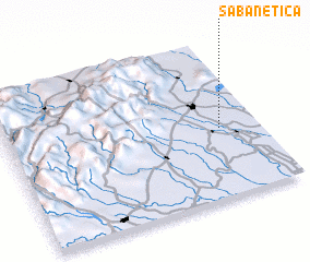 Places with similar names to Sabanetica, Venezuela ::
// Cibenda 2 (ID)
// Sabanetica (VE)
// Sabanetica (VE)
// Sabanetica (VE)
// Sabanetica (VE)
// Sabon Duku (NG)
// Zabantigui (ML)
// Subandaku (PH)
// Sabanetica (DO)
// Sobonoydokh (RU)
Disclaimer :: Information on this page comes without warranty of any kind |
||
|
Where is Sabanetica? Elevation and coordinates ::
Latitude (lat): 9°26'53"N Longitude (lon): 69°9'4"W
Elevation (approx.): 157m (map arrows pan, magnifying glasses zoom) |
||
|
Visiting Sabanetica? Hotel/Accommodation ::
Book a hotel in Sabanetica Travel Guide ::
Buy a travel guide for Venezuela rental cars ::
car rental offers GPS waypoint ::
download a GPX waypoint (PoI) of Sabanetica for your GPS receiver
|
||