|
search place name
|
||
San Antonio de Guachero (Apure, Venezuela)San Antonio de Guachero is a town in the Apure region of Venezuela. An overview map of the region around San Antonio de Guachero is displayed below.
regional and 3d topo map of San Antonio de Guachero, Venezuela ::

San Antonio de Guachero airports ::
The nearest airport is SFD - San Fernando De Apure, located 95.7 km north of San Antonio de Guachero.
Other airports nearby include PCR - Puerto Carreno (96.7 km south), PYH - Puerto Ayacucho Casique Aramare (160.3 km south), Nearby towns ::
Mata Larga (3.4km east) //
Mata de Camino (3.9km west) //
Mata Sola (5.7km north east) //
San Miguel Urañón (7.8km south east) //
San Francisco (8.2km north east) //
Las Mercedes (8.9km south) //
Santa Ana (9.1km south west) //
[all distances 'as the bird flies' and approximate] 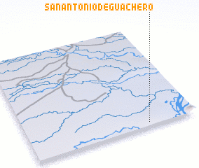 Places with similar names to San Antonio de Guachero, Venezuela :: Disclaimer :: Information on this page comes without warranty of any kind |
||
|
Where is San Antonio de Guachero? Elevation and coordinates ::
Latitude (lat): 7°2'0"N Longitude (lon): 67°17'0"W
Elevation (approx.): 53m (map arrows pan, magnifying glasses zoom) |
||
|
Visiting San Antonio de Guachero? Hotel/Accommodation ::
Book a hotel in San Antonio de Guachero Travel Guide ::
Buy a travel guide for Venezuela rental cars ::
car rental offers GPS waypoint ::
download a GPX waypoint (PoI) of San Antonio de Guachero for your GPS receiver
|
||