|
search place name
|
||
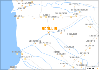
San Luis (Trujillo, Venezuela)San Luis is a town in the Trujillo region of Venezuela. An overview map of the region around San Luis is displayed below.
regional and 3d topo map of San Luis, Venezuela ::
San Luis airports ::
The nearest airport is VLV - Valera Dr Antonio Nicolas Briceno, located 41.8 km east of San Luis.
Other airports nearby include MRD - Merida Alberto Carnevalli (94.9 km south), STB - Santa Barbara Del Zulia (118.9 km south west), BNS - Barinas (119.6 km south east), GUQ - Guanare (138.9 km east), Nearby towns ::
Los Verales (4.2km south west) //
Jacinta (4.3km east) //
El Catorce (6.2km north) //
Los Rurales (6.3km south west) //
El Doce (6.9km north) //
El Cinco (7.6km north west) //
Caroní (7.9km south) //
Zona Rica (8.3km north east) //
Santa Apolonia (8.5km north west) //
El Diecisiete (8.7km north east) //
Los Ejidos (8.6km east) //
Mete Miedo (9.2km south east) //
La Recría (9.3km south east) //
Boyacá (10.6km north east) //
[all distances 'as the bird flies' and approximate] 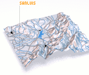 Places with similar names to San Luis, Venezuela ::
Disclaimer :: Information on this page comes without warranty of any kind |
||
|
Where is San Luis? Elevation and coordinates ::
Latitude (lat): 9°24'58"N Longitude (lon): 70°57'25"W
Elevation (approx.): 12m (map arrows pan, magnifying glasses zoom) |
||
|
Visiting San Luis? Hotel/Accommodation ::
Book a hotel in San Luis Travel Guide ::
Buy a travel guide for Venezuela rental cars ::
car rental offers GPS waypoint ::
download a GPX waypoint (PoI) of San Luis for your GPS receiver
|
||