|
search place name
|
||
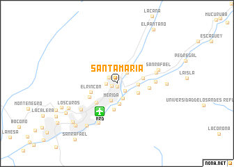
Santa María (Mérida, Venezuela)Santa María is a town in the Mérida region of Venezuela. An overview map of the region around Santa María is displayed below.
regional and 3d topo map of Santa María, Venezuela ::
Santa María airports ::
The nearest airport is MRD - Merida Alberto Carnevalli, located 5.2 km south west of Santa María.
Other airports nearby include STB - Santa Barbara Del Zulia (96.9 km north west), VLV - Valera Dr Antonio Nicolas Briceno (100.0 km north east), BNS - Barinas (100.7 km east), LFR - La Fria (132.0 km west), Nearby towns ::
Santa Marta (0.5km south) //
Santa Ana (0.9km south west) //
Chorros de Milla (1.2km north) //
San Pedro (1.6km north west) //
Santa Rosa (1.7km west) //
Mesa de La Virgen (1.7km south east) //
Vallecito (2.4km north east) //
Lourdes (2.6km south) //
Mérida (2.9km south) //
La Perla (3.4km south) //
Las Calaveras (3.4km east) //
San Antonio (3.6km south east) //
San Jacinto (4.2km south) //
Los Llanitos (4.3km east) //
Las Mercedes (4.3km north east) //
El Rincón (4.4km west) //
San José (4.5km south west) //
Loma de La Virgen (4.9km south west) //
Mucunután (5.2km east) //
El Salado (6.2km east) //
Tabay (6.4km east) //
San Rafael (6.9km east) //
Las Tienditas (7.0km south west) //
Urbanización La Pedregosa (7.1km south west) //
La Mucuy (7.8km east) //
El Chamita (8.3km south west) //
Los Curos (8.6km south west) //
La Parroquia (9.4km south west) //
La Punta (9.4km south west) //
[all distances 'as the bird flies' and approximate] 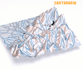 Places with similar names to Santa María, Venezuela ::
// Santa Maria (BR)
// Santa Maria (BR)
// Santa Maria (BR)
// Santa Maria (BR)
// Santa Maria (BR)
// Santa Maria (BR)
// Santa Maria (BR)
// Santa Maria (BR)
// Santa Maria (BR)
// Santa Maria (BR)
Disclaimer :: Information on this page comes without warranty of any kind |
||
|
Where is Santa María? Elevation and coordinates ::
Latitude (lat): 8°37'21"N Longitude (lon): 71°8'10"W
Elevation (approx.): 1787m (map arrows pan, magnifying glasses zoom) |
||
|
Visiting Santa María? Hotel/Accommodation ::
Book a hotel in Santa María Travel Guide ::
Buy a travel guide for Venezuela rental cars ::
car rental offers GPS waypoint ::
download a GPX waypoint (PoI) of Santa María for your GPS receiver
|
||