|
search place name
|
||
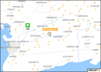
Sarinao (Falcón, Venezuela)Sarinao is a town in the Falcón region of Venezuela. An overview map of the region around Sarinao is displayed below.
regional and 3d topo map of Sarinao, Venezuela ::
Sarinao airports ::
The nearest airport is LSP - Paraguana Josefa Camejo, located 9.1 km north west of Sarinao.
Other airports nearby include CZE - Coro Jose Leonardo Chirinos (56.5 km south east), AUA - Oranjestad Reina Beatrix Intl (83.9 km north), CUR - Willemstad Hato (131.1 km east), BON - Kralendijk Flamingo (201.5 km east), Nearby towns ::
Cerro Atravesado (2.1km south) //
Guaricuche (2.5km north) //
Quitaire (2.8km west) //
Supidero (3.2km south east) //
Galera (3.3km south) //
Santa Rita (3.8km north west) //
Cují Macho (4.3km north) //
Santa Fe (4.9km east) //
San Antonio (5.2km west) //
La Trinidad (5.4km west) //
El Hato (5.5km south west) //
San Marcos (5.5km west) //
Yabuquiva (5.6km north) //
Bella Vista (5.7km south west) //
Guaricure (6.4km west) //
Cunacho (6.5km east) //
San Joaquín (6.9km south west) //
Caseto (7.3km east) //
Santa Cruz (7.6km north east) //
Davaduvare (8.3km north east) //
Saquatumo (9.2km north east) //
Guaranaro (9.5km south west) //
Paso de León (9.7km south east) //
El Cayude (10.9km south east) //
San Nicolás (11.2km north east) //
[all distances 'as the bird flies' and approximate]  Places with similar names to Sarinao, Venezuela ::
Disclaimer :: Information on this page comes without warranty of any kind |
||
|
Where is Sarinao? Elevation and coordinates ::
Latitude (lat): 11°44'44"N Longitude (lon): 70°4'34"W
Elevation (approx.): 32m (map arrows pan, magnifying glasses zoom) |
||
|
Visiting Sarinao? Hotel/Accommodation ::
Book a hotel in Sarinao Travel Guide ::
Buy a travel guide for Venezuela rental cars ::
car rental offers GPS waypoint ::
download a GPX waypoint (PoI) of Sarinao for your GPS receiver
|
||