|
search place name
|
||
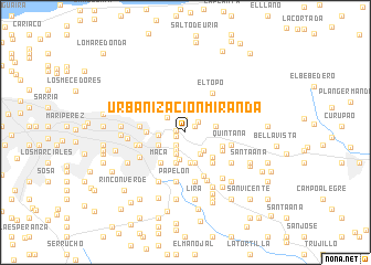
Urbanización Miranda (Miranda, Venezuela)Urbanización Miranda is a town in the Miranda region of Venezuela. An overview map of the region around Urbanización Miranda is displayed below.
regional and 3d topo map of Urbanización Miranda, Venezuela ::
Urbanización Miranda airports ::
The nearest airport is CCS - Caracas Simon Bolivar Intl, located 26.5 km north west of Urbanización Miranda.
Other airports nearby include VLN - Valencia Arturo Michelena Intl (132.0 km west), PBL - Puerto Cabello General Bartolome Salom Intl (142.1 km west), VDP - Valle De La Pascua (164.8 km south east), SFH - San Felipe Sub Teniente Nestor Arias (218.2 km west), Nearby towns ::
La Cortada (0.9km west) //
La Dolorita (1.0km south west) //
Resbalón (1.1km north east) //
El Cacho (1.1km north east) //
Santa Rosa (1.2km north) //
El Coche (1.5km south west) //
Ayala (1.7km north east) //
La Fenix (2.0km south west) //
Urbanización Guaicoco (2.3km south west) //
Piritu (2.4km north west) //
Urbanización Turumo (2.6km south east) //
El Respiro (2.6km north east) //
Urbanización El Rodeo (2.6km south east) //
La Urbina (2.8km west) //
Valle Alto (2.8km south) //
Los Limoncitos (3.0km south west) //
El Sitio (3.1km south) //
El Milagro (3.1km east) //
El Calvario (3.2km north) //
Guaricoco (3.2km south) //
Urbanización Mi Refugio (3.2km south) //
Cabeza de Tigre (3.2km south) //
El Deleite (3.5km north east) //
La Providencia (3.7km south east) //
La Cortada (3.9km north east) //
Maca (3.9km south west) //
Urbanización Santa Elena (3.9km east) //
El Marqués (3.9km west) //
Urbanización Maturín (4.1km south east) //
[all distances 'as the bird flies' and approximate] 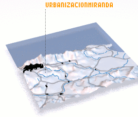 Places with similar names to Urbanización Miranda, Venezuela :: Disclaimer :: Information on this page comes without warranty of any kind |
||
|
Where is Urbanización Miranda? Elevation and coordinates ::
Latitude (lat): 10°29'40"N Longitude (lon): 66°46'30"W
Elevation (approx.): 1038m (map arrows pan, magnifying glasses zoom) |
||
|
Visiting Urbanización Miranda? Hotel/Accommodation ::
Book a hotel in Urbanización Miranda Travel Guide ::
Buy a travel guide for Venezuela rental cars ::
car rental offers GPS waypoint ::
download a GPX waypoint (PoI) of Urbanización Miranda for your GPS receiver
|
||