|
search place name
|
||
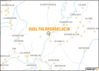
Vuelta Larga de Lucía (Zulia, Venezuela)Vuelta Larga de Lucía is a town in the Zulia region of Venezuela. An overview map of the region around Vuelta Larga de Lucía is displayed below.
regional and 3d topo map of Vuelta Larga de Lucía, Venezuela ::
Vuelta Larga de Lucía airports ::
The nearest airport is LFR - La Fria, located 64.0 km south east of Vuelta Larga de Lucía.
Other airports nearby include STB - Santa Barbara Del Zulia (80.2 km east), CUC - Cucuta Camilo Daza (86.6 km south), OCV - Ocana Aguas Claras (92.0 km south west), SVZ - San Antonio Del Tachira (97.4 km south), Nearby towns ::
Boca del Roto (1.8km south) //
Socorro (2.2km south) //
El Pozón de Lucía (2.2km north east) //
Kilómetro Uno (2.3km north) //
Monte Adentro (3.5km west) //
Santa Lucía (4.0km north east) //
Playa de La Ciénaga (4.6km north east) //
Alcabala (5.1km south east) //
Playa El Rincón (6.8km north east) //
Mi Delirio (6.8km east) //
Albaricales (7.5km north east) //
Pata de Gallina (8.5km east) //
Tres Bocas (10.0km south west) //
El Mirador (11.1km south west) //
Los Laurles (11.8km south west) //
[all distances 'as the bird flies' and approximate]  Places with similar names to Vuelta Larga de Lucía, Venezuela :: Disclaimer :: Information on this page comes without warranty of any kind |
||
|
Where is Vuelta Larga de Lucía? Elevation and coordinates ::
Latitude (lat): 8°42'10"N Longitude (lon): 72°37'10"W
Elevation (approx.): 35m (map arrows pan, magnifying glasses zoom) |
||
|
Visiting Vuelta Larga de Lucía? Hotel/Accommodation ::
Book a hotel in Vuelta Larga de Lucía Travel Guide ::
Buy a travel guide for Venezuela rental cars ::
car rental offers GPS waypoint ::
download a GPX waypoint (PoI) of Vuelta Larga de Lucía for your GPS receiver
|
||