|
search place name
|
||
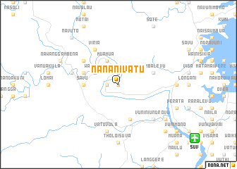
Nananivatu (Fiji)Nananivatu is a town in Fiji. An overview map of the region around Nananivatu is displayed below.
regional and 3d topo map of Nananivatu, Fiji ::
Nananivatu airports ::
The nearest airport is SUV - Nausori Intl, located 14.3 km south east of Nananivatu.
Other airports nearby include NAN - Nandi Nadi Intl (109.2 km west), LMG - Lambasa Labasa (191.1 km north east), Nearby towns ::
Nakini (0.0km north) //
Ndelandamanu (1.9km north) //
Mbaulevu (1.8km west) //
Nathokaika (1.8km west) //
Natoaika (1.9km north) //
Tovutovu (1.8km west) //
Wainikia (4.0km north west) //
Muamua (4.1km north west) //
Savu (5.3km west) //
Naisonggo (5.6km west) //
Sawani (5.8km south) //
Tumbalevu (5.6km east) //
Viria (6.6km north west) //
Lami (6.5km north west) //
Nangavungavu (6.5km north west) //
Vatuvula (7.6km south) //
Nanggali (7.3km west) //
Vuniniundrovu (7.7km south east) //
Navuso (9.0km south east) //
Sarava (10.2km south east) //
Mataleka (10.2km north west) //
Navuto (10.2km north west) //
[all distances 'as the bird flies' and approximate] 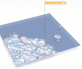 Places with similar names to Nananivatu, Fiji :: Disclaimer :: Information on this page comes without warranty of any kind |
||
|
Where is Nananivatu? Elevation and coordinates ::
Latitude (lat): 17°58'0"S Longitude (lon): 178°27'0"E
Elevation (approx.): 37m (map arrows pan, magnifying glasses zoom) |
||
|
Visiting Nananivatu? Hotel/Accommodation ::
Book a hotel in Nananivatu Travel Guide ::
Buy a travel guide for Fiji rental cars ::
car rental offers GPS waypoint ::
download a GPX waypoint (PoI) of Nananivatu for your GPS receiver
|
||