|
search place name
|
||
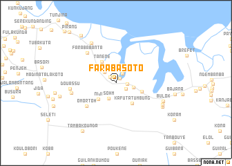
Faraba Soto (Western, Gambia, The)Faraba Soto is a town in the Western region of Gambia, The. An overview map of the region around Faraba Soto is displayed below.
regional and 3d topo map of Faraba Soto, Gambia, The ::
Faraba Soto airports ::
The nearest airport is BJL - Banjul Intl, located 23.5 km north west of Faraba Soto.
Other airports nearby include ZIG - Ziguinchor (75.0 km south), CSK - Cap Skiring (92.2 km south), KLC - Kaolack (114.4 km north east), BXO - Bissau Oswaldo Vieira Intl (170.6 km south east), Nearby towns ::
Kanjiramba (0.9km north east) //
Hamdalae (1.3km north west) //
Tuman Tenda (1.8km north east) //
Fula Kunda (1.8km south east) //
Kafuta (1.8km east) //
Bessi Nding (2.5km north west) //
Suma Kunda Koto (2.8km north) //
Sohm (2.8km south west) //
Kafuta (2.9km east) //
Sotokoi (3.4km north west) //
Niji (3.8km south west) //
Tanene (4.1km north west) //
Kafuta Tumbung (4.1km south east) //
Sanianga (4.3km east) //
Omortoh (6.0km south west) //
Faraba Banta (6.7km north west) //
Jenun Kunda (7.2km west) //
Douassu (7.3km west) //
Faraba Banta (7.5km north west) //
Bulok (8.0km east) //
Kapongah (8.2km south east) //
Kanjiramba (8.3km south east) //
Tambakounda (9.4km south west) //
Pirang (9.5km north west) //
Pirang (11.0km north west) //
Bonto (11.6km north west) //
[all distances 'as the bird flies' and approximate] 
Disclaimer :: Information on this page comes without warranty of any kind |
||
|
Where is Faraba Soto? Elevation and coordinates ::
Latitude (lat): 13°12'12"N Longitude (lon): 16°29'4"W
Elevation (approx.): 23m (map arrows pan, magnifying glasses zoom) |
||
|
Visiting Faraba Soto? Hotel/Accommodation ::
Book a hotel in Faraba Soto Travel Guide ::
Buy a travel guide for Gambia, The rental cars ::
car rental offers GPS waypoint ::
download a GPX waypoint (PoI) of Faraba Soto for your GPS receiver
|
||