|
search place name
|
||
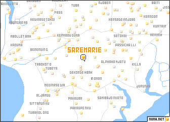
Sare Marie (Western, Gambia, The)Sare Marie is a town in the Western region of Gambia, The. An overview map of the region around Sare Marie is displayed below.
regional and 3d topo map of Sare Marie, Gambia, The ::
Sare Marie airports ::
The nearest airport is BJL - Banjul Intl, located 33.8 km south west of Sare Marie.
Other airports nearby include KLC - Kaolack (81.8 km north east), ZIG - Ziguinchor (102.5 km south), CSK - Cap Skiring (124.8 km south), DKR - Dakar Leopold Sedar Senghor Intl (184.4 km north west), Nearby towns ::
Demba Hainey (1.6km south west) //
Fass Omar Sahor (2.0km south west) //
Ker Sait Cham (2.3km east) //
Alpha (2.9km south east) //
Alpha NʼDing (2.9km south east) //
Sare Chikam (3.1km east) //
Dekordeh Bah (3.6km south) //
Ker Sirrai (3.6km north east) //
Yala (4.1km north west) //
Medina Seringe Mass (4.1km west) //
Ker Samba NʼJabeh (4.3km north east) //
Njambour (4.5km south west) //
Madina Bafuloto (4.5km south east) //
Chamen (4.9km north) //
NʼGeyen (5.0km north east) //
Suturah (5.1km north east) //
Bangali (5.1km north west) //
Sara Juma (5.3km south) //
Ker Samba Kalla (5.4km north) //
Mahmuda (5.5km south west) //
Samba Secka (5.5km south west) //
Inoman (5.6km south east) //
Ker Mama Hugo (5.7km south west) //
Ker MʼBouguma (5.7km north west) //
Pakela Demba Colleh (5.8km south) //
Bangali (5.7km north west) //
Ker Ngumbo (5.9km south east) //
Medina Dudu (6.2km south east) //
Ker Biran Kani (6.4km east) //
[all distances 'as the bird flies' and approximate] 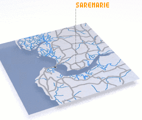 Places with similar names to Sare Marie, Gambia, The ::
// Şura Mare (RO)
// Sarıömer (TR)
// Soromaray (MG)
// Soromaray (MG)
// Surīmāra (BD)
// Soroumbara (BF)
// Soroumboura (BF)
// Zaoromera (CF)
// Sarāi Mīr (IN)
// Sarmera (IN)
Disclaimer :: Information on this page comes without warranty of any kind |
||
|
Where is Sare Marie? Elevation and coordinates ::
Latitude (lat): 13°28'41"N Longitude (lon): 16°22'28"W
Elevation (approx.): 32m (map arrows pan, magnifying glasses zoom) |
||
|
Visiting Sare Marie? Hotel/Accommodation ::
Book a hotel in Sare Marie Travel Guide ::
Buy a travel guide for Gambia, The rental cars ::
car rental offers GPS waypoint ::
download a GPX waypoint (PoI) of Sare Marie for your GPS receiver
|
||