|
search place name
|
||
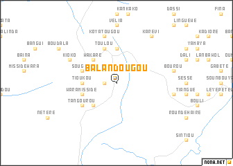
Balandougou (Mali, Guinea)Balandougou is a town in the Mali region of Guinea. An overview map of the region around Balandougou is displayed below.
regional and 3d topo map of Balandougou, Guinea ::
Balandougou airports ::
The nearest airport is KGG - Kedougou, located 73.2 km north east of Balandougou.
Other airports nearby include LEK - Labe (88.5 km south east), FIG - Fira Fria (214.0 km south west), TUD - Tambacounda (217.0 km north west), Nearby towns ::
Kounboukoto (1.8km west) //
Sakadi (5.2km north west) //
Wakaré (5.2km north west) //
Pété (5.2km south west) //
Tioukou (5.4km west) //
Erabiniaré (5.6km north) //
Féloura (5.7km west) //
Kalango (5.7km west) //
Koura (5.8km north) //
Sougué (5.7km west) //
Toulou (5.8km north) //
Védou (5.7km west) //
Wara Missidé (5.7km west) //
Bantiniel (6.6km south west) //
Tangourou (6.6km south west) //
Idayatou (6.6km south west) //
Koyatougou (7.6km north) //
Kioko (8.1km north west) //
Godioliré (8.1km north west) //
Karévi (9.2km north east) //
[all distances 'as the bird flies' and approximate] 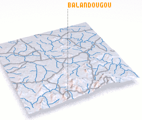 Places with similar names to Balandougou, Guinea ::
// Balindog (PH)
// Blandikow (DE)
// Bilindik (TR)
// Balandagou (BF)
// Balandugu (SL)
// Balandougou (GN)
// Balandougou (GN)
// Balandougou (GN)
// Balandougou (GN)
// Balandougou (GN)
Disclaimer :: Information on this page comes without warranty of any kind |
||
|
Where is Balandougou? Elevation and coordinates ::
Latitude (lat): 12°3'0"N Longitude (lon): 12°38'0"W
Elevation (approx.): 547m (map arrows pan, magnifying glasses zoom) |
||
|
Visiting Balandougou? Hotel/Accommodation ::
Book a hotel in Balandougou Travel Guide ::
Buy a travel guide for Guinea rental cars ::
car rental offers GPS waypoint ::
download a GPX waypoint (PoI) of Balandougou for your GPS receiver
|
||