|
search place name
|
||
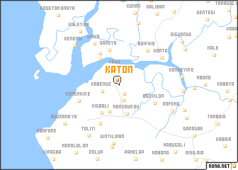
Katon (Forécariah, Guinea)Katon is a town in the Forécariah region of Guinea. An overview map of the region around Katon is displayed below.
regional and 3d topo map of Katon, Guinea ::
Katon airports ::
The nearest airport is FNA - Freetown Lungi, located 57.7 km south of Katon.
Other airports nearby include FIG - Fira Fria (139.8 km north), Nearby towns ::
Palatougui (1.6km south east) //
Karankoné (2.5km south) //
Tawa (2.5km north) //
Kabendo (2.8km west) //
Kompa (4.4km south) //
Monkourou (4.7km south) //
Benti (5.0km north west) //
Kigbali (5.2km south west) //
Saréya (5.8km north) //
Kakoutoulaye (5.8km north west) //
Benkilon (6.2km south east) //
Romenkiné (6.7km west) //
Diguipali (6.8km south west) //
Boifiko (7.0km north east) //
Sinka (7.5km north west) //
Konta (8.0km north east) //
Taliyi (9.3km south west) //
Kénendi (9.3km north west) //
Roféma (9.3km south east) //
Kaleyiré (10.3km north west) //
Bouramaya (10.4km south west) //
[all distances 'as the bird flies' and approximate] 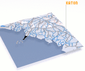 Places with similar names to Katon, Guinea ::
Disclaimer :: Information on this page comes without warranty of any kind |
||
|
Where is Katon? Elevation and coordinates ::
Latitude (lat): 9°8'18"N Longitude (lon): 13°12'25"W
Elevation (approx.): 6m (map arrows pan, magnifying glasses zoom) |
||
|
Visiting Katon? Hotel/Accommodation ::
Book a hotel in Katon Travel Guide ::
Buy a travel guide for Guinea rental cars ::
car rental offers GPS waypoint ::
download a GPX waypoint (PoI) of Katon for your GPS receiver
|
||